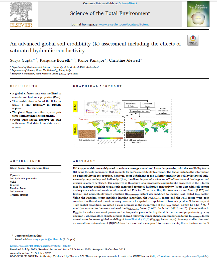
This dataset encompasses global soil erodibility (K) factor maps, with the K factor being estimated through the Wischmeier and Smith (1978) method. The equation incorporates permeability information crudely and indirectly, mainly relying on soil texture details, potentially overlooking factors like vegetation, biopores, and clay minerals. To address this limitation, we integrated measured Ksat values, representing soil hydraulic properties, into the Wischmeier and Smith (1978) soil texture-based K factor equation (referred to as KWischmeier factor) to formulate the Ksat-based soil erodibility (Kksat factor) map. Our dataset consists of approximately 6000 measured Ksat samples worldwide, linked with environmental covariates using the quantile random forest algorithm to generate 1 km spatial resolution maps for both Ksat and KWischmeier factors. Additionally, we calculated uncertainty for the Kksat and KWischmeier factor maps, represented by 90% prediction intervals (PI) through quantile calculations at 0.05 and 0.95. This uncertainty assessment was performed using the quantreg option in the R package ‘ranger’ (Wright and Ziegler 2015), termed as Uncertainty Kksat and Uncertainty KWischmeier. Comparisons were made between the Kksat and KWischmeier factor maps and Borrelli et al. (2017) KGloSEM factor map. The results indicated a reduction in Kksat factor values in tropical regions, highlighting differences in soil properties such as clay and iron. In contrast, other climate regions exhibited relatively minor changes compared to both the KWischmeier factor and Borrelli et al. 2017 KGloSEM factor map.
Important notice: For European use, we recommend the European K-factor dataset
Reference: Gupta, S., Borrelli, P., Panagos, P., Alewell, C., 2024. An advanced global soil erodibility (K) assessment including the effects of saturated hydraulic conductivity. Science of The Total Environment 908, 168249. https://doi.org/10.1016/j.scitotenv.2023.168249
Datasets - Three raster maps are available plus two uncertainties maps:
Title: K_factor_with_Ksat.tif
Description: The modified global soil erodibility map (Kksat factor) where the measured Ksat values were incorporated into the Wischmeier and Smith (1978) soil texture-based K factor equation.
Title: K_factor_soiltexture_Wischmeier.tif
Description: The global soil erodibility map (KWischmeier factor raster) where the Wischmeier and Smith (1978) soil texture-based K factor equation was used without Ksat modification.
Title: K_GloSEM_factor.tif
Description: The KGloSEM soil erodibility map (KGloSEM factor) was developed by Borrelli et al. (2017), where they employed soil texture as a proxy for permeability, similar to the KWischmeier factor. We used this existing map to compare it with the Kksat factor map. The original spatial resolution of this map was 250 m, however, we resampled it to 1 km for comparison.
Title: K_factor_with_Ksat_error.tif
Description: The modified global soil erodibility map (Uncertainty raster of Kksat factor) errors represented by 90% prediction intervals (PI) through quantile calculations at 0.05 and 0.95. This uncertainty assessment was performed using the quantreg option in the R package ‘ranger’ (Wright and Ziegler 2015).
Title: K_factor_soiltexture_Wischmeier_error.tif
Description: The global soil erodibility map (Uncertainty raster of KWischmeier factor) errors represented by 90% prediction intervals (PI) through quantile calculations at 0.05 and 0.95. This uncertainty assessment was performed using the quantreg option in the R package ‘ranger’ (Wright and Ziegler 2015).
Spatial coverage: World , Extent: -180.00, -62.00: 180.00, 87.3
Pixel size: 1km.
Measurement Unit: t ha h ha-1 MJ-1 mm-1
Projection: EPSG:4326 - WGS 84