Citation: Selvaradjou, S-K., L. Montanarella, O. Spaargaren and D. Dent (2005). European Digital Archive of Soil Maps (EuDASM) - Soil Maps of Asia DVD-ROM version. EUR 21823 EN. Office of the Official Publications of the European Communities, Luxembourg.
Iraq
| Title: |
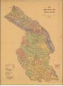
Exploratory Soil Map of Iraq. Map 1.
|
|
| Author(s): |
Buringh, P.;
|
|
| Publication year: |
1957
|
|
| Publisher(s): |
Ministry of Agriculture, Baghdad.
|
|
| Language: |
En Ar
|
|
| Coordinates: |
N37°15 - N29°50
E45°0 - E48°45
|
|
| Scale: |
1,000,000
|
|
| Keyword(s): |
Soil
|
| Title: |
Location Map. Soils and Soil Conditions in Iraq. Map 2.
|
|
| Author(s): |
Buringh, P.;
|
|
| Publication year: |
1957
|
|
| Publisher(s): |
Ministry of Agriculture, Baghdad.
|
|
| Language: |
En Ar
|
|
| Coordinates: |
N37°15 - N29°50
E45°0 - E48°45
|
|
| Scale: |
3,000,000
|
|
| Keyword(s): |
Soil; Topography
|
| Title: |
Baghdad. North I-38.
|
|
| Author(s): |
From a Middle East Map MDR 1/1361 of April 1944.
|
|
| Publication year: |
1945
|
|
| Publisher(s): |
War Office.
|
|
| Language: |
En
|
|
| Coordinates: |
N36°0 - N32°0
E42°0 - E48°0
|
|
| Scale: |
1,000,000
|
|
| Keyword(s): |
Topography
|
| Title: |
Semi-Detailed Soil Map of the Hussainiyah-Beni Hassan Project. Appendix 1.
|
|
| Author(s): |
Schilstra, J.;
|
|
| Publication year: |
1958
|
|
| Publisher(s): |
Directorate General of Agricultural Research and Projects, Baghdad. Division of Soils and Agricultural Chemistry, Abu Ghraib.
|
|
| Language: |
En
|
|
| Coordinates: |
N35°30 - N35°0
E44°10 - E44°40
|
|
| Scale: |
1,000,000
|
|
| Keyword(s): |
Soil
|
| Title: |
Pedogenetic Soil Salinity Map of the Hussainiyah-Beni Hassan Project. Appendix 2.
|
|
| Author(s): |
Schilstra, J.;
|
|
| Publication year: |
1958
|
|
| Publisher(s): |
Directorate General of Agricultural Research and Projects, Baghdad. Division of Soils and Agricultural Chemistry, Abu Ghraib.
|
|
| Language: |
En
|
|
| Coordinates: |
N35°30 - N35°0
E44°10 - E44°40
|
|
| Scale: |
1,000,000
|
|
| Keyword(s): |
Soil
|
| Title: |
Soil Drainage Condition Map of the Hussainiyah-Beni Hassan Project. Appendix 3.
|
|
| Author(s): |
Schilstra, J.;
|
|
| Publication year: |
1958
|
|
| Publisher(s): |
Directorate General of Agricultural Research and Projects, Baghdad. Division of Soils and Agricultural Chemistry, Abu Ghraib.
|
|
| Language: |
En
|
|
| Coordinates: |
N35°30 - N35°0
E44°10 - E44°40
|
|
| Scale: |
1,000,000
|
|
| Keyword(s): |
Soil
|
| Title: |
Soil Suitability Map for Agricultural Use under the Present Local Conditions of the Hussainiyah-Beni Hassan Project. Appendix 4.
|
|
| Author(s): |
Schilstra, J.;
|
|
| Publication year: |
1958
|
|
| Publisher(s): |
Directorate General of Agricultural Research and Projects, Baghdad. Division of Soils and Agricultural Chemistry, Abu Ghraib.
|
|
| Language: |
En
|
|
| Coordinates: |
N35°30 - N35°0
E44°10 - E44°40
|
|
| Scale: |
1,000,000
|
|
| Keyword(s): |
Soil
|
| Title: |
Soil Suitability Map for Potential Agricultural Use of the Hussainiyah-Beni Hassan Project. Appendix 5.
|
|
| Author(s): |
Schilstra, J.;
|
|
| Publication year: |
1958
|
|
| Publisher(s): |
Directorate General of Agricultural Research and Projects, Baghdad. Division of Soils and Agricultural Chemistry, Abu Ghraib.
|
|
| Language: |
En
|
|
| Coordinates: |
N35°30 - N35°0
E44°10 - E44°40
|
|
| Scale: |
1,000,000
|
|
| Keyword(s): |
Soil
|
| Title: |
Provisional Soil Associations Map of Al-Jezira.
|
|
| Author(s): |
Altaie, F.H.;
|
|
| Publisher(s): |
State Organization of Soil and Land Reclamation.
|
|
| Language: |
En
|
|
| Coordinates: |
N35°30 - N35°0
E40°0 - E40°30
|
|
| Scale: |
250,000
|
|
| Keyword(s): |
Soil
|
| Title: |
Iraq. Upper Diyala Area. Present Land Use.
|
|
| Publication year: |
1958
|
|
| Language: |
En
|
|
| Coordinates: |
N35°30 - N34°0
E44°30 - E45°30
|
|
| Scale: |
100,000
|
|
| Keyword(s): |
Land use
|
| Title: |
Reconnaissance Soil Survey Map of Alton-Kopri Project.
|
|
| Author(s): |
Altaie, F.H.;
|
|
| Publication year: |
1973
|
|
| Publisher(s): |
Ministry of Irrigation, Directorate General of Soils & Reclamation, Division of Soil Survey & Land Classification, Republic of Iraq.
|
|
| Language: |
En
|
|
| Coordinates: |
N35°40 - N35°30
E44°10 - E44°30
|
|
| Scale: |
100,000
|
|
| Keyword(s): |
Soil
|
| Title: |
Land Capability Map of Alton-Kopri Project.
|
|
| Author(s): |
Altaie, F.H.;
|
|
| Publication year: |
1973
|
|
| Publisher(s): |
Ministry of Irrigation, Directorate General of Soils & Reclamation, Division of Soil Survey & Land Classification, Republic of Iraq.
|
|
| Language: |
En
|
|
| Coordinates: |
N35°40 - N35°30
E44°10 - E44°30
|
|
| Scale: |
100,000
|
|
| Keyword(s): |
Soil suitability
|
| Title: |
Semi-Detailed Soil Survey Map of Selected Area (in Alton-Kopri).
|
|
| Author(s): |
Altaie, F.H.;
|
|
| Publication year: |
1973
|
|
| Publisher(s): |
Ministry of Irrigation, Directorate General of Soils & Reclamation, Division of Soil Survey & Land Classification, Republic of Iraq.
|
|
| Language: |
En
|
|
| Coordinates: |
N35°40 - N35°30
E44°10 - E44°30
|
|
| Scale: |
25,000
|
|
| Keyword(s): |
Soil
|
| Title: |
Land Capability Map of Selected Area (in Alton-Kopri).
|
|
| Author(s): |
Altaie, F.H.;
|
|
| Publication year: |
1973
|
|
| Publisher(s): |
Ministry of Irrigation, Directorate General of Soils & Reclamation, Division of Soil Survey & Land Classification, Republic of Iraq.
|
|
| Language: |
En
|
|
| Coordinates: |
N35°40 - N35°30
E44°10 - E44°30
|
|
| Scale: |
25,000
|
|
| Keyword(s): |
Soil suitability
|
| Title: |
Lower Khalis Project. Map 1. Soils. DRG. No. LK/76.
|
|
| Publication year: |
1975
|
|
| Publisher(s): |
Sir M. Macdonald & Partners Consulting Engineers in Assocciation with Hunting Technical Services Ltd.
|
|
| Language: |
En
|
|
| Coordinates: |
N33°51 - N33°21
E44°18 - E44°39
|
|
| Scale: |
50,000
|
|
| Keyword(s): |
Soil
|
| Title: |
Lower Khalis Project. Map 2. Salinity. DRG. No. LK/77.
|
|
| Publication year: |
1975
|
|
| Publisher(s): |
Sir M. Macdonald & Partners Consulting Engineers in Assocciation with Hunting Technical Services Ltd.
|
|
| Language: |
En
|
|
| Coordinates: |
N33°51 - N33°21
E44°18 - E44°39
|
|
| Scale: |
50,000
|
|
| Keyword(s): |
Soil management
|
| Title: |
Lower Khalis Project. Map 3. Land Classification. DRG. No. LK/78.
|
|
| Publication year: |
1975
|
|
| Publisher(s): |
Sir M. Macdonald & Partners Consulting Engineers in Assocciation with Hunting Technical Services Ltd.
|
|
| Language: |
En
|
|
| Coordinates: |
N33°51 - N33°21
E44°18 - E44°39
|
|
| Scale: |
50,000
|
|
| Keyword(s): |
Soil
|
| Title: |
Lower Khalis Project. Map 4. Drainability. DRG. No. LK/79.
|
|
| Publication year: |
1975
|
|
| Publisher(s): |
Sir M. Macdonald & Partners Consulting Engineers in Assocciation with Hunting Technical Services Ltd.
|
|
| Language: |
En
|
|
| Coordinates: |
N33°51 - N33°21
E44°18 - E44°39
|
|
| Scale: |
50,000
|
|
| Keyword(s): |
Soil
|
| Title: |
Lower Khalis Project. Map 5. Pressure. DRG. No. LK/80.
|
|
| Publication year: |
1975
|
|
| Publisher(s): |
Sir M. Macdonald & Partners Consulting Engineers in Assocciation with Hunting Technical Services Ltd.
|
|
| Language: |
En
|
|
| Coordinates: |
N33°51 - N33°21
E44°18 - E44°39
|
|
| Scale: |
50,000
|
|
| Keyword(s): |
Soil
|
| Title: |
Lower Khalis Project. Map 6. Reclamation. DRG. No. LK/81.
|
|
| Publication year: |
1975
|
|
| Publisher(s): |
Sir M. Macdonald & Partners Consulting Engineers in Assocciation with Hunting Technical Services Ltd.
|
|
| Language: |
En
|
|
| Coordinates: |
N33°51 - N33°21
E44°18 - E44°39
|
|
| Scale: |
50,000
|
|
| Keyword(s): |
Soil
|
| Title: |
Lower Khalis Project. Map 7. Development Planning. DRG. No. LK/82.
|
|
| Publication year: |
1975
|
|
| Publisher(s): |
Sir M. Macdonald & Partners Consulting Engineers in Assocciation with Hunting Technical Services Ltd.
|
|
| Language: |
En
|
|
| Coordinates: |
N33°51 - N33°21
E44°18 - E44°39
|
|
| Scale: |
50,000
|
|
| Keyword(s): |
Land use
|
| Title: |
Land Classification Survey. Lower Diyala Area. Map No. LD. 9. Grid Reference 2c. 14.
|
|
| Author(s): |
Diyala and Middle Tigris Projects.
|
|
| Publisher(s): |
Sir M. Macdonald & Partners Consulting Engineers, London.
|
|
| Language: |
En
|
|
| Coordinates: |
N33°45 - N33°30
E44°45 - E45°0
|
|
| Scale: |
50,000
|
|
| Keyword(s): |
Soil
|
|


![[Download]](../images/maps/download/IQ2000_1SO.jpg)
![[Download]](../images/maps/download/IQ2000_2SO.jpg)
![[Download]](../images/maps/download/IQ2001_TO.jpg)
![[Download]](../images/maps/download/IQ2002_1SO.jpg)
![[Download]](../images/maps/download/IQ2002_3SO.jpg)
![[Download]](../images/maps/download/IQ2002_4SO.jpg)
![[Download]](../images/maps/download/IQ2002_4SOX.jpg)
![[Download]](../images/maps/download/IQ2002_5SO.jpg)
![[Download]](../images/maps/download/IQ3000_SO.jpg)
![[Download]](../images/maps/download/IQ3001_LU.jpg)
![[Download]](../images/maps/download/IQ3002_1SO.jpg)
![[Download]](../images/maps/download/IQ3002_2SO.jpg)
![[Download]](../images/maps/download/IQ3002_3SO.jpg)
![[Download]](../images/maps/download/IQ3002_4SO.jpg)
![[Download]](../images/maps/download/IQ4000_1SO.jpg)
![[Download]](../images/maps/download/IQ4000_2SM.jpg)
![[Download]](../images/maps/download/IQ4000_3SO.jpg)
![[Download]](../images/maps/download/IQ4000_4.jpg)
![[Download]](../images/maps/download/IQ4000_5.jpg)
![[Download]](../images/maps/download/IQ4000_6.jpg)
![[Download]](../images/maps/download/IQ4000_7.jpg)
![[Download]](../images/maps/download/IQ4001.jpg)