
Citation: Selvaradjou, S-K., L. Montanarella, O. Spaargaren and D. Dent (2005). European Digital Archive of Soil Maps (EuDASM) - Soil Maps of Asia DVD-ROM version. EUR 21823 EN. Office of the Official Publications of the European Communities, Luxembourg.
| Title: | ASSOD- Status of Human-Induced Soil Degradation in South and Southeast Asia: Dominant Degradation Type. |
|---|---|
| Author(s): | ISRIC, Wageningen. |
| Publication year: | 1997 |
| Publisher(s): | ISRIC, FAO, UNEP. |
| Country: | XA XE RU MN JP PH VN TH KH MM MY BD BT IN PK AF IR IQ QA SY LB IL AE YE OM SA TR EG ID PG LK KW |
| Language: | En |
| Coordinates: | Latitude: N80°0 - S11°0 Longitude: E35°0 - E135°0 |
| Scale: | 18,000,000 |
| Keyword(s): | Soil |
| Title: | ASSOD- Status of Human-Induced Soil Degradation in South and Southeast Asia: Extent and Impact of Degradation. | |
|---|---|---|
| Author(s): | ISRIC, Wageningen. | |
| Publication year: | 1997 | |
| Publisher(s): | ISRIC, FAO, UNEP. | |
| Country: | XA XE RU MN JP PH VN TH KH MM MY BD BT IN PK AF IR IQ SY LB IL QA AE YE OM SA TR EG ID PG LK KW | |
| Language: | En | |
| Coordinates: | Latitude: N80°0 - S11°0 Longitude: E35°0 - E135°0 | |
| Scale: | 18,000,000 | |
| Keyword(s): | Soil |
| Title: | Bangladesh. Land Satellite Digital Mosaic. 1984. Sheet 2. Land Zones and Land Systems. | |
|---|---|---|
| Author(s): | Space Research and Remote Sensing Organization (SPARRSO) Government of the People's Republic of Bangladesh. | |
| Publication year: | 1990 | |
| Publisher(s): | United States Agency for International Development (USAID). | |
| Language: | En | |
| Coordinates: | N26°40 - N21°0 E88°5 - E92°50 | |
| Scale: | 1,000,000 | |
| Keyword(s): | Satellite image |
| Title: | Bangladesh. Land Satellite Digital Mosaic. 1984. Sheet 3. Land Use Types. | |
|---|---|---|
| Author(s): | Space Research and Remote Sensing Organization (SPARRSO) Government of the People's Republic of Bangladesh. | |
| Publication year: | 1990 | |
| Publisher(s): | United States Agency for International Development (USAID). | |
| Language: | En | |
| Coordinates: | N26°40 - N21°0 E88°5 - E92°50 | |
| Scale: | 1,000,000 | |
| Keyword(s): | Satellite image |
| Title: | Bangladesh. Land Satellite Digital Mosaic. 1984. Sheet 4. Forest Areas. | |
|---|---|---|
| Author(s): | Space Research and Remote Sensing Organization (SPARRSO) Government of the People's Republic of Bangladesh. | |
| Publication year: | 1990 | |
| Publisher(s): | United States Agency for International Development (USAID). | |
| Language: | En | |
| Coordinates: | N26°40 - N21°0 E88°5 - E92°50 | |
| Scale: | 1,000,000 | |
| Keyword(s): | Satellite map |
| Title: | Soil Map of the People's Republic of China. [Revised Version Based on the FAO/Unesco Soil Map of the World]. | |
|---|---|---|
| Author(s): | Fengrong, Z.; | |
| Publication year: | 1990 | |
| Publisher(s): | State Land Administration, China. | |
| Language: | En | |
| Coordinates: | N54°0 - N19°0 E74°0 - E135°0 | |
| Scale: | 5,000,000 | |
| Keyword(s): | Soil |
| Title: | The Land Type Map of the Huang Huai Hai Plain. | |
|---|---|---|
| Publication year: | 1991 | |
| Publisher(s): | ISBN 7-5030-0460-6/K168 | |
| Language: | Zh En | |
| Coordinates: | N39°50 - ° E112°10 - ° | |
| Scale: | 500,000 | |
| Keyword(s): | Soil |
| Title: | The Land Type Map of the Huang Huai Hai Plain. | |
|---|---|---|
| Publication year: | 1991 | |
| Publisher(s): | ISBN 7-5030-0460-6/K168 | |
| Language: | Zh En | |
| Coordinates: | N39°50 - N37°50 E112°10 - E117°0 | |
| Scale: | 500,000 | |
| Keyword(s): | Soil, Land use |
| Title: | The Land Type Map of the Huang Huai Hai Plain. | |
|---|---|---|
| Publication year: | 1991 | |
| Publisher(s): | ISBN 7-5030-0460-6/K168 | |
| Language: | Zh En | |
| Coordinates: | N40°20 - N37°50 E117°0 - E123°0 | |
| Scale: | 500,000 | |
| Keyword(s): | Soil, Land use |
| Title: | The Land Type Map of the Huang Huai Hai Plain. | |
|---|---|---|
| Publication year: | 1991 | |
| Publisher(s): | ISBN 7-5030-0460-6/K168 | |
| Language: | Zh En | |
| Coordinates: | N37°50 - N34°35 E117°0 - E123°0 | |
| Scale: | 500,000 | |
| Keyword(s): | Soil, Land use |
| Title: | The Land Type Map of the Huang Huai Hai Plain. | |
|---|---|---|
| Publication year: | 1991 | |
| Publisher(s): | ISBN 7-5030-0460-6/K168 | |
| Language: | Zh En | |
| Coordinates: | N37°50 - N34°35 E112°45 - E117°0 | |
| Scale: | 500,000 | |
| Keyword(s): | Soil, Land use |
| Title: | The Land Type Map of the Huang Huai Hai Plain. | |
|---|---|---|
| Publication year: | 1991 | |
| Publisher(s): | ISBN 7-5030-0460-6/K168 | |
| Language: | Zh En | |
| Coordinates: | N34°35 - N31°35 E112°45 - E117°0 | |
| Scale: | 500,000 | |
| Keyword(s): | Soil, Land use |
| Title: | The Land Type Map of the Huang Huai Hai Plain. Legend. | |
|---|---|---|
| Publication year: | 1991 | |
| Publisher(s): | ISBN 7-5030-0460-6/K168 | |
| Language: | Zh En | |
| Coordinates: | N34°35 - N31°35 E117°30 - E122°45 | |
| Scale: | 500,000 | |
| Keyword(s): | Soil, Land use |
| Title: | Land Use. India. Plate 13. National Atlas of India. | |
|---|---|---|
| Publication year: | 1992 | |
| Publisher(s): | Government of India. | |
| Language: | En | |
| Coordinates: | N37°0 - N7°0 E68°0 - E96°0 | |
| Scale: | 6,000,000 | |
| Keyword(s): | Land use; Topography |
| Title: | Land Use. India. Plate 13. National Atlas of India. legend | |
|---|---|---|
| Publication year: | 1992 | |
| Publisher(s): | Government of India. | |
| Language: | En | |
| Coordinates: | N37°0 - N7°0 E68°0 - E96°0 | |
| Scale: | 6,000,000 | |
| Keyword(s): | Land use; Topography |
| Title: | Agro-Ecological Regions. India. | |
|---|---|---|
| Author(s): | Sehgal, J.L.; Mandal, D.K.; Mandal, C.; Vadivelu, S.; | |
| Publication year: | 1990 | |
| Publisher(s): | National Bureau of Soil Survey & Land Use Planning, Nagpur. | |
| Language: | En | |
| Coordinates: | N36°0 - N8°0 E68°0 - E96°0 | |
| Scale: | 5,000,000 | |
| Keyword(s): | Climate; Climatology; Physical geography; Soil; Topography |
| Title: | Agro-Ecological Regions. India. | |
|---|---|---|
| Author(s): | Sehgal, J.L.; Mandal, D.K.; Mandal, C.; Vadivelu, S.; | |
| Publication year: | 1992 | |
| Publisher(s): | National Bureau of Soil Survey & Land Use Planning, Nagpur. | |
| Language: | En | |
| Coordinates: | N36°0 - N8°0 E68°0 - E96°0 | |
| Scale: | 5,000,000 | |
| Keyword(s): | Climate; Climatology; Physical geography; Soil |
| Title: | Soil Degradation. India. Human-Induced-3rd Approximation. | |
|---|---|---|
| Author(s): | Sehgal, J.; Saxena, R.K.; Pofali, R.M.; | |
| Publication year: | 1994 | |
| Publisher(s): | Oxford & IBH Publishing Co. PVT. LTD., New Delhi. | |
| Language: | En | |
| Coordinates: | N36°40 - N8°0 E68°0 - E98°10 | |
| Scale: | 4,400,000 | |
| Keyword(s): | Soil |
| Title: | India. Agro-Ecological Subregions. | |
|---|---|---|
| Author(s): | Sehgal, J.L.; Mandal, D.K.; Mandal, C.; | |
| Publication year: | 1996 | |
| Publisher(s): | National Bureau of Soil Survey (NBSS) and Land Use Planning (LUP), Nagpur. | |
| Language: | En | |
| Coordinates: | N36°10 - N7°55 E67°50 - E94°0 | |
| Scale: | 4,400,000 | |
| Keyword(s): | Climate; Climatology |
| Title: | Haryana. Soils. Sheet 1. | |
|---|---|---|
| Author(s): | Seghal, J.; | |
| Publication year: | 1994 | |
| Publisher(s): | National Bureau of Soil Survey & Land Use Planning, Nagpur. | |
| Language: | En | |
| Coordinates: | N31°0 - N27°40 E74°30 - E77°10 | |
| Scale: | 500,000 | |
| Keyword(s): | Soil; Topography |
| Title: | Haryana. Soils. Sheet 2. | |
|---|---|---|
| Author(s): | Seghal, J.; | |
| Publication year: | 1994 | |
| Publisher(s): | National Bureau of Soil Survey & Land Use Planning, Nagpur. | |
| Language: | En | |
| Coordinates: | N31°0 - N27°40 E74°30 - E77°10 | |
| Scale: | 500,000 | |
| Keyword(s): | Soil; Topography |
| Title: | TAMIL NADU. Soils. Sheet 3. | |
|---|---|---|
| Author(s): | Seghal, J.; | |
| Publication year: | 1994 | |
| Publisher(s): | National Bureau of Soil Survey & Land Use Planning, Nagpur. | |
| Language: | En | |
| Coordinates: | ||
| Scale: | 500,000 | |
| Keyword(s): | Soil; Topography |
| Title: | Punjab. Soils. Sheet 1. | |
|---|---|---|
| Author(s): | Seghal, J.; | |
| Publication year: | 1994 | |
| Publisher(s): | National Bureau of Soil Survey & Land Use Planning, Nagpur. | |
| Language: | En | |
| Coordinates: | N32°20 - N29°50 E74°0 - E77°0 | |
| Scale: | 500,000 | |
| Keyword(s): | Soil; Topography |
| Title: | Punjab. Soils. Sheet 2. | |
|---|---|---|
| Author(s): | Seghal, J.; | |
| Publication year: | 1994 | |
| Publisher(s): | National Bureau of Soil Survey & Land Use Planning, Nagpur. | |
| Language: | En | |
| Coordinates: | N32°20 - N29°50 E74°0 - E77°0 | |
| Scale: | 500,000 | |
| Keyword(s): | Soil; Topography |
| Title: | Karaikal Region. Soils. Observations. Physiography. | |
|---|---|---|
| Publication year: | 1992 | |
| Publisher(s): | National Bureau of Soil Survey (NBSS) and Land Use Planning (LUP), Nagpur. | |
| Language: | En | |
| Coordinates: | N11°0 - N10°50 E79°40 - E79°50 | |
| Scale: | 100,000 | |
| Keyword(s): | Physical geography; Soil |
| Title: | Karaikal Region. Land Capability. Land Irrigability. Problem Soils. Productive Soils. | |
|---|---|---|
| Publication year: | 1992 | |
| Publisher(s): | National Bureau of Soil Survey (NBSS) and Land Use Planning (LUP), Nagpur. | |
| Language: | En | |
| Coordinates: | N11°0 - N10°50 E79°40 - E79°50 | |
| Scale: | 100,000 | |
| Keyword(s): | Land use; Soil management; Soil suitability |
| Title: | Karaikal Region. Soil Suitability for Cotton, Pulses, Rice. Suggested Land Use. | |
|---|---|---|
| Publication year: | 1992 | |
| Publisher(s): | National Bureau of Soil Survey (NBSS) and Land Use Planning (LUP), Nagpur. | |
| Language: | En | |
| Coordinates: | N11°0 - N10°50 E79°40 - E79°50 | |
| Scale: | 100,000 | |
| Keyword(s): | Land use; Soil suitability |
| Title: | Pondicherry Region. Soils. Physiography. Observations. | |
|---|---|---|
| Publication year: | 1992 | |
| Publisher(s): | National Bureau of Soil Survey (NBSS) and Land Use Planning (LUP), Nagpur. | |
| Language: | En | |
| Coordinates: | N12°0 - N11°50 E79°40 - E79°50 | |
| Scale: | 100,000 | |
| Keyword(s): | Physical geography; Soil |
| Title: | Pondicherry Region. Land Capability. Land Irrigability. Productive Soils. Problem | |
|---|---|---|
| Publication year: | 1992 | |
| Publisher(s): | National Bureau of Soil Survey (NBSS) and Land Use Planning (LUP), Nagpur. | |
| Language: | En | |
| Coordinates: | N12°0 - N11°50 E79°40 - E79°50 | |
| Scale: | 100,000 | |
| Keyword(s): | Land use; Soil management; Soil suitability |
| Title: | Pondichery Region. Soil Suitability for rice, Sugarcane, Millets, Groundnut. | |
|---|---|---|
| Publication year: | 1992 | |
| Publisher(s): | National Bureau of Soil Survey (NBSS) and Land Use Planning (LUP), Nagpur. | |
| Language: | En | |
| Coordinates: | N12°0 - N11°50 E79°40 - E79°50 | |
| Scale: | 100,000 | |
| Keyword(s): | Soil suitability |
| Title: | Pondichery Region. Soil Suitability for, Vegetables, Flower Plants, Suggested Land Use. | |
|---|---|---|
| Publication year: | 1992 | |
| Publisher(s): | National Bureau of Soil Survey (NBSS) and Land Use Planning (LUP), Nagpur. | |
| Language: | En | |
| Coordinates: | N12°0 - N11°50 E79°40 - E79°50 | |
| Scale: | 100,000 | |
| Keyword(s): | Land use; Soil suitability |
| Title: | Tripura. Soils. Sheet 1. | |
|---|---|---|
| Author(s): | Bhattacharyya, T.; Sehgal, J.; Sarkar, D.; | |
| Publication year: | 1996 | |
| Publisher(s): | National Bureau of Soil Survey (NBSS) and Land Use Planning (LUP), Nagpur. Country: BD | |
| Language: | En | |
| Coordinates: | N25°0 - N23°0 E91°10 - E92°30 | |
| Scale: | 250,000 | |
| Keyword(s): | Soil |
| Title: | Tripura. Soils. Sheet 2. Legend. | |
|---|---|---|
| Author(s): | Bhattacharyya, T.; Sehgal, J.; Sarkar, D.; | |
| Publication year: | 1996 | |
| Publisher(s): | National Bureau of Soil Survey (NBSS) and Land Use Planning (LUP), Nagpur. Country: BD | |
| Language: | En | |
| Coordinates: | N25°0 - N23°0 E91°10 - E92°30 | |
| Scale: | 250,000 | |
| Keyword(s): | Soil |
| Title: | Maharashtra. Soils. Sheet 1. | |
|---|---|---|
| Author(s): | Challa, O.; Vadivelu, S.; Sehgal, J.; | |
| Publication year: | 1996 | |
| Publisher(s): | National Bureau of Soil Survey (NBSS) and Land Use Planning (LUP), Nagpur. Country: BD | |
| Language: | En | |
| Coordinates: | N22°0 - N15°40 E73°0 - E81°0 | |
| Scale: | 500,000 | |
| Keyword(s): | Soil |
| Title: | Maharashtra. Soils. Sheet 2. | |
|---|---|---|
| Author(s): | Challa, O.; Vadivelu, S.; Sehgal, J.; | |
| Publication year: | 1996 | |
| Publisher(s): | National Bureau of Soil Survey (NBSS) and Land Use Planning (LUP), Nagpur. Country: BD | |
| Language: | En | |
| Coordinates: | N22°0 - N15°40 E73°0 - E81°0 | |
| Scale: | 500,000 | |
| Keyword(s): | Soil |
| Title: | Maharashtra. Soils. Sheet 3. | |
|---|---|---|
| Author(s): | Challa, O.; Vadivelu, S.; Sehgal, J.; | |
| Publication year: | 1996 | |
| Publisher(s): | National Bureau of Soil Survey (NBSS) and Land Use Planning (LUP), Nagpur. Country: BD | |
| Language: | En | |
| Coordinates: | N22°0 - N15°40 E73°0 - E81°0 | |
| Scale: | 500,000 | |
| Keyword(s): | Soil |
| Title: | Maharashtra. Soils. Sheet 4. | |
|---|---|---|
| Author(s): | Challa, O.; Vadivelu, S.; Sehgal, J.; | |
| Publication year: | 1996 | |
| Publisher(s): | National Bureau of Soil Survey (NBSS) and Land Use Planning (LUP), Nagpur. Country: BD | |
| Language: | En | |
| Coordinates: | N22°0 - N15°40 E73°0 - E81°0 | |
| Scale: | 500,000 | |
| Keyword(s): | Soil |
| Title: | Maharashtra. Soils. Sheet 5. | |
|---|---|---|
| Author(s): | Challa, O.; Vadivelu, S.; Sehgal, J.; | |
| Publication year: | 1996 | |
| Publisher(s): | National Bureau of Soil Survey (NBSS) and Land Use Planning (LUP), Nagpur. Country: BD | |
| Language: | En | |
| Coordinates: | N22°0 - N15°40 E73°0 - E81°0 | |
| Scale: | 500,000 | |
| Keyword(s): | Soil |
| Title: | Maharashtra. Soils. Sheet 6. | |
|---|---|---|
| Author(s): | Challa, O.; Vadivelu, S.; Sehgal, J.; | |
| Publication year: | 1996 | |
| Publisher(s): | National Bureau of Soil Survey (NBSS) and Land Use Planning (LUP), Nagpur. Country: BD | |
| Language: | En | |
| Coordinates: | N22°0 - N15°40 E73°0 - E81°0 | |
| Scale: | 500,000 | |
| Keyword(s): | Soil |
| Title: | Karnataka. Soils. Sheet 1. | |
|---|---|---|
| Author(s): | Sehgal, J.L.; Hirekerur, L.R.; Sarma, V.A.K.; | |
| Publication year: | 1996 | |
| Publisher(s): | National Bureau of Soil Survey (NBSS) and Land Use Planning (LUP), Nagpur. Country: BD | |
| Language: | En | |
| Coordinates: | N18°30 - N11°30 E74°10 - E78°40 | |
| Scale: | 500,000 | |
| Keyword(s): | Soil |
| Title: | Karnataka. Soils. Sheet 2. | |
|---|---|---|
| Author(s): | Sehgal, J.L.; Hirekerur, L.R.; Sarma, V.A.K.; | |
| Publication year: | 1996 | |
| Publisher(s): | National Bureau of Soil Survey (NBSS) and Land Use Planning (LUP), Nagpur. Country: BD | |
| Language: | En | |
| Coordinates: | N18°30 - N11°30 E74°10 - E78°40 | |
| Scale: | 500,000 | |
| Keyword(s): | Soil |
| Title: | Karnataka. Soils. Sheet 3. | |
|---|---|---|
| Author(s): | Sehgal, J.L.; Hirekerur, L.R.; Sarma, V.A.K.; | |
| Publication year: | 1996 | |
| Publisher(s): | National Bureau of Soil Survey (NBSS) and Land Use Planning (LUP), Nagpur. Country: BD | |
| Language: | En | |
| Coordinates: | N18°30 - N11°30 E74°10 - E78°40 | |
| Scale: | 500,000 | |
| Keyword(s): | Soil |
| Title: | Karnataka. Soils. Sheet 4. | |
|---|---|---|
| Author(s): | Sehgal, J.L.; Hirekerur, L.R.; Sarma, V.A.K.; | |
| Publication year: | 1996 | |
| Publisher(s): | National Bureau of Soil Survey (NBSS) and Land Use Planning (LUP), Nagpur. Country: BD | |
| Language: | En | |
| Coordinates: | N18°30 - N11°30 E74°10 - E78°40 | |
| Scale: | 500,000 | |
| Keyword(s): | Soil |
| Title: | Tamil Nadu. Soils. Sheet 1. | |
|---|---|---|
| Author(s): | Natarajan, A.; Reddy,P.S.A.; Sehgal, J.; Velayutham, M.; | |
| Publication year: | 1996 | |
| Publisher(s): | National Bureau of Soil Survey (NBSS) and Land Use Planning (LUP), Nagpur. Country: BD | |
| Language: | En | |
| Coordinates: | N13°30 - N8°5 E76°10 - E80°20 | |
| Scale: | 500,000 | |
| Keyword(s): | Soil |
| Title: | Tamil Nadu. Soils. Sheet 2. | |
|---|---|---|
| Author(s): | Natarajan, A.; Reddy,P.S.A.; Sehgal, J.; Velayutham, M.; | |
| Publication year: | 1996 | |
| Publisher(s): | National Bureau of Soil Survey (NBSS) and Land Use Planning (LUP), Nagpur. Country: BD | |
| Language: | En | |
| Coordinates: | N13°30 - N8°5 E76°10 - E80°20 | |
| Scale: | 500,000 | |
| Keyword(s): | Soil |
| Title: | Tamil Nadu. Soils. Sheet 4. | |
|---|---|---|
| Author(s): | Natarajan, A.; Reddy,P.S.A.; Sehgal, J.; Velayutham, M.; | |
| Publication year: | 1996 | |
| Publisher(s): | National Bureau of Soil Survey (NBSS) and Land Use Planning (LUP), Nagpur. Country: BD | |
| Language: | En | |
| Coordinates: | N13°30 - N8°5 E76°10 - E80°20 | |
| Scale: | 500,000 | |
| Keyword(s): | Soil |
| Title: | Kerala. Soils. Sheet 1. | |
|---|---|---|
| Author(s): | Krishnan, P.; Venugopal, K.R.; Sehgal, J.; | |
| Publication year: | 1996 | |
| Publisher(s): | National Bureau of Soil Survey (NBSS) and Land Use Planning (LUP), Nagpur. Country: BD | |
| Language: | En | |
| Coordinates: | N12°50 - N8°10 E75°0 - E77°10 | |
| Scale: | 500,000 | |
| Keyword(s): | Soil |
| Title: | Kerala. Soils. Sheet 2. | |
|---|---|---|
| Author(s): | Krishnan, P.; Venugopal, K.R.; Sehgal, J.; | |
| Publication year: | 1996 | |
| Publisher(s): | National Bureau of Soil Survey (NBSS) and Land Use Planning (LUP), Nagpur. Country: BD | |
| Language: | En | |
| Coordinates: | N12°50 - N8°10 E75°0 - E77°10 | |
| Scale: | 500,000 | |
| Keyword(s): | Soil |
| Title: | Manipur. Soils. | |
|---|---|---|
| Author(s): | Krishnan, P.; Venugopal, K.R.; Sehgal, J.; | |
| Publication year: | 1996 | |
| Publisher(s): | National Bureau of Soil Survey (NBSS) and Land Use Planning (LUP), Nagpur. Country: BD | |
| Language: | En | |
| Coordinates: | N12°50 - N8°10 E75°0 - E77°10 | |
| Scale: | 500,000 | |
| Keyword(s): | Soil |
| Title: | Soil Map of Japan. Legend. (Legend available in Map-Room!!) [JP-2002] | |
|---|---|---|
| Author(s): | Nagatsuka, S.; Okazaki, M.; | |
| Publication year: | 1990 | |
| Language: | En Ja | |
| Scale: | 2,000,000 | |
| Keyword(s): | Soil |
| Title: | Soil Map of Japan. Central Japan. (Legend available in Map-Room!!) [JP-2002] | |
|---|---|---|
| Author(s): | Nagatsuka, S.; Okazaki, M.; | |
| Publication year: | 1990 | |
| Language: | En Ja | |
| Coordinates: | N38°10 - N32°0 E133°30 - E143°30 | |
| Scale: | 2,000,000 | |
| Keyword(s): | Soil |
| Title: | Soil Map of Japan. Northern Japan. (Legend available in Map-Room!!) [JP-2002] | |
|---|---|---|
| Author(s): | Nagatsuka, S.; Okazaki, M.; | |
| Publication year: | 1990 | |
| Language: | En Ja | |
| Coordinates: | N46°0 - N37°30 E137°50 - E146°10 | |
| Scale: | 2,000,000 | |
| Keyword(s): | Soil |
| Title: | Soil Map of Japan. Southwest Japan. (Legend available in Map-Room!!) [JP-2002] | |
|---|---|---|
| Author(s): | Nagatsuka, S.; Okazaki, M.; | |
| Publication year: | 1990 | |
| Language: | En Ja | |
| Coordinates: | N36°30 - N24°0 E128°10 - E135°30 | |
| Scale: | 2,000,000 | |
| Keyword(s): | Soil |
| Title: | Pakistan. Generalized Soil Map. | |
|---|---|---|
| Publication year: | 1993 | |
| Publisher(s): | Soil Survey of Pakistan. Lahore. | |
| Language: | En | |
| Coordinates: | N38°0 - N23°0 E61°0 - E78°0 | |
| Scale: | 2,000,000 | |
| Keyword(s): | Soil |
| Title: | Pakistan. Soil Reaction. Calcareousness. Salinity. Sodicity. | |
|---|---|---|
| Author(s): | Tahir, M.A.; Anwar, M.; Din, A.; Ilyas, M.; Akhtar, N.A.; Ahmad, M.; | |
| Publication year: | 1994 | |
| Publisher(s): | Soil Survey of Pakistan. Lahore. | |
| Language: | En | |
| Coordinates: | N38°0 - N23°0 E61°0 - E78°0 | |
| Scale: | 1,500,000 | |
| Keyword(s): | Soil management |
| Title: | Trincomalee District. Land Use. | |
|---|---|---|
| Publication year: | 1990 | |
| Publisher(s): | Survey Department of Sri Lanka. | |
| Language: | En | |
| Coordinates: | N9°20 - N8°0 E81°0 - E81°30 | |
| Scale: | 100,000 | |
| Keyword(s): | Land use |
| Title: | Syria from Space. GSIM 1000: GSIM SYR-S1. | |
|---|---|---|
| Author(s): | Geospace. | |
| Publication year: | 1995 | |
| Publisher(s): | European Academy of Sciences and Arts, Academia Scientiarum et Artium Europaea, Institute for Global Mapping and Research. | |
| Language: | En Ar | |
| Coordinates: | Latitude N37°30 - N32°0 Longitude E35°30 - E42°30 | |
| Scale: | 1,000,000 | |
| Keyword(s): | Saterlite image |
| Title: | Forest Resources of Papua New Guinea. Sheet 1. | |
|---|---|---|
| Author(s): | Saunders, J.C.; | |
| Publication year: | 1993 | |
| Publisher(s): | Australian International Development Assistance Bureau, Canberra. | |
| Language: | En | |
| Coordinates: | Latitude: S7°0 - S9°0 Longitude: E141°0 - E148°0 | |
| Scale: | 1,000,000 | |
| Keyword(s): | Land use |
| Title: | Forest Resources of Papua New Guinea. Sheet 2. | |
|---|---|---|
| Author(s): | Saunders, J.C.; | |
| Publication year: | 1993 | |
| Publisher(s): | Australian International Development Assistance Bureau, Canberra. | |
| Language: | En | |
| Coordinates: | Latitude: S3°30 - S7°0 Longitude: E141°0 - E148°0 | |
| Scale: | 1,000,000 | |
| Keyword(s): | Land use |
| Title: | Forest Resources of Papua New Guinea. Sheet 3. | |
|---|---|---|
| Author(s): | Saunders, J.C.; | |
| Publication year: | 1993 | |
| Publisher(s): | Australian International Development Assistance Bureau, Canberra. | |
| Language: | En | |
| Coordinates: | Latitude: S3°30 - S7°0 Longitude: E147°50 - E154°30 | |
| Scale: | 1,000,000 | |
| Keyword(s): |
| Title: | Forest Resources of Papua New Guinea. Sheet 4. | |
|---|---|---|
| Author(s): | Saunders, J.C.; | |
| Publication year: | 1993 | |
| Publisher(s): | Australian International Development Assistance Bureau, Canberra. | |
| Language: | En | |
| Coordinates: | Latitude: S7°0 - S11°30 Longitude: E147°50 - E154°30 | |
| Scale: | 1,000,000 | |
| Keyword(s): |
| Title: | Agricultural Land Use of Papua New Guinea. Sheet 1. | |
|---|---|---|
| Author(s): | Saunders, J.C.; | |
| Publication year: | 1993 | |
| Publisher(s): | Australian International Development Assistance Bureau, Canberra. | |
| Language: | En | |
| Coordinates: | Latitude: S7°0 - S11°30 Longitude: E141°0 - E148°0 | |
| Scale: | 1,000,000 | |
| Keyword(s): | Land use |
| Title: | Agricultural Land Use of Papua New Guinea. Sheet 2. | |
|---|---|---|
| Author(s): | Saunders, J.C.; | |
| Publication year: | 1993 | |
| Publisher(s): | Australian International Development Assistance Bureau, Canberra. | |
| Language: | En | |
| Coordinates: | Latitude: S7°0 - S11°30 Longitude: E147°30 - E154°30 | |
| Scale: | 1,000,000 | |
| Keyword(s): | Land use |
| Title: | Agricultural Land Use of Papua New Guinea. Sheet 3. | |
|---|---|---|
| Author(s): | Saunders, J.C.; | |
| Publication year: | 1993 | |
| Publisher(s): | Australian International Development Assistance Bureau, Canberra. | |
| Language: | En | |
| Coordinates: | Latitude: S2°30 - S7°0 Longitude: E141°0 - E148°0 | |
| Scale: | 1,000,000 | |
| Keyword(s): | Land use |
| Title: | Agricultural Land Use of Papua New Guinea. Sheet 4. | |
|---|---|---|
| Author(s): | Saunders, J.C.; | |
| Publication year: | 1993 | |
| Publisher(s): | Australian International Development Assistance Bureau, Canberra. | |
| Language: | En | |
| Coordinates: | Latitude: S2°30 - S7°0 Longitude: E147°30 - E154°30 | |
| Scale: | 1,000,000 | |
| Keyword(s): | Land use |
| Title: | Overzichtskaart van het Eiland Sumatra. Overzicht van de Politieke Indeeling van Sumatra. | |
|---|---|---|
| Publication year: | 1996 | |
| Publisher(s): | Herdruk Topografische Dienst Nederland en Koninklijk Instituut voor de Tropen. | |
| Language: | NL | |
| Coordinates: | Latitude N5°50 - S6°5 Longitude E95°0 - E106°5 | |
| Scale: | 1,650,000 | |
| Keyword(s): | Physical geography; Social geography; Topography |
| Title: | Peta Tanah Semi Detil. Daerah Istimewa Yogyakarta. 5019-1. [Semi-Detailed Soil Map. Yogyakarta Province.] | |
|---|---|---|
| Author(s): | Muslihat, L.; Soleh, Ngadimin, H.; | |
| Publication year: | 1995 | |
| Publisher(s): | Centre for Soil and Agroclimate Research. | |
| Language: | In En | |
| Coordinates: | Latitude S7°40 - S7°50 Longitude E110°15 - E110°30 | |
| Scale: | 50,000 | |
| Keyword(s): | Soil |
| Title: | Peta Tanah Semi Detil. Daerah Nusadua-Padangbai. Propinsi Bali. 1707-33. [Semi-Detailed Soil Map. Nusadua-Padangbai Area. Bali Province.] | |
|---|---|---|
| Author(s): | Siswanto, A.B.; Margomulyono, E.; Bhekti, H.; | |
| Publication year: | 1995 | |
| Publisher(s): | Centre for Soil and Agroclimate Research. | |
| Language: | In En | |
| Coordinates: | Latitude S30°0 - S45°0 Longitude E0°0 - E15°0 | |
| Scale: | 50,000 | |
| Keyword(s): | Soil |
| Title: | Plattegrond van Batavia. | |
|---|---|---|
| Publication year: | 1995 | |
| Language: | Nl | |
| Coordinates: | Latitude S6°5 - S6°15 Longitude E106°45 - E106°55 | |
| Scale: | 20,000 | |
| Keyword(s): | Topography |
| Title: | Plattegrond van Batavia. BACKSIDE LEGEND | |
|---|---|---|
| Publication year: | 1995 | |
| Language: | Nl | |
| Coordinates: | Latitude S6°5 - S6°15 Longitude E106°45 - E106°55 | |
| Scale: | 20,000 | |
| Keyword(s): | Topography |
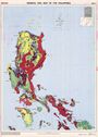
| Title: | General Soil Map of the Philippines. Legend. | |
|---|---|---|
| Author(s): | Alcasid, G.N. Jr.; | |
| Publication year: | 1995 | |
| Publisher(s): | Department of Agriculture. Bureau of Soils and Water Management. | |
| Language: | En | |
| Keyword(s): | Soil |
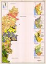
| Title: | General Soil Map of the Philippines. Sheet 1. | |
|---|---|---|
| Author(s): | Alcasid, G.N. Jr.; | |
| Publication year: | 1995 | |
| Publisher(s): | Department of Agriculture. Bureau of Soils and Water Management. | |
| Language: | En | |
| Coordinates: | Latitude N22°0 - N12°0 Longitude E120°30 - E126°0 | |
| Scale: | 1,000,000 | |
| Keyword(s): | Soil |
| Title: | General Soil Map of the Philippines. Sheet 2. | |
|---|---|---|
| Author(s): | Alcasid, G.N. Jr.; | |
| Publication year: | 1995 | |
| Publisher(s): | Department of Agriculture. Bureau of Soils and Water Management. | |
| Language: | En | |
| Coordinates: | Latitude N12°0 - N4°50 Longitude E117°0 - E121°0 | |
| Scale: | 1,000,000 | |
| Keyword(s): | Soil |
| Title: | General Soil Map of the Philippines. Sheet 3. | |
|---|---|---|
| Author(s): | Alcasid, G.N. Jr.; | |
| Publication year: | 1995 | |
| Publisher(s): | Department of Agriculture. Bureau of Soils and Water Management. | |
| Language: | En | |
| Coordinates: | Latitude N12°0 - N4°50 Longitude E121°0 - E126°30 | |
| Scale: | 1,000,000 | |
| Keyword(s): | Soil |
| Title | A Geomorphological Survey Map of the Kraseio River Basin in the Western Part of the Central Plain of Thailand Showing Classification of Flood-inundated Areas. | |
|---|---|---|
| Author(s): | Ohkura, H.; Haruyama, S.; (et al.) | |
| Publication year: | 1991 | |
| Language: | En | |
| Coordinates: | Latitude N15°5 - N14°20 Longitude E99°35 - E100°10 | |
| Scale: | 100,000 | |
| Keyword(s): | Physical geography |
| Title | Geomorphlogical Land Classification Map of the Northern Coast of the Sagami Bay. | |
|---|---|---|
| Author(s): | Masahiko, O.; Matsubara, A.; | |
| Publication year: | 1991 | |
| Language: | En | |
| Coordinates: | Latitude N35°22 - N35°13 Longitude E138°50 - E139°23 | |
| Scale: | 100,000 | |
| Keyword(s): | Physical geography |
| Title | Changwat Suphan Buri. Series 1501 S. Sheet ND 47-7. | |
|---|---|---|
| Publication year: | 1992 | |
| Publisher(s): | Royal Thai Survey Department, Supreme Command Headquaters for Civilian purpose. | |
| Language: | En Th | |
| Coordinates: | Latitude N15°0 - N14°0 Longitude E99°0 - E100°30 | |
| Scale: | 250,000 | |
| Keyword(s): | Topography; Vegetation |
| Title | Changwat Nakhon Phanom. Series 1501 S. Sheet NE 48-10. | |
|---|---|---|
| Publication year: | 1991 | |
| Publisher(s): | Royal Thai Survey Department, Supreme Command Headquaters for Civilian purpose. | |
| Language: | En Th | |
| Coordinates: | Latitude N18°0 - N17°0 Longitude E103°30 - E105°0 | |
| Scale: | 250,000 | |
| Keyword(s): | Topography; Vegetation |
| Title | Soil Resources of Gia Lai Province. | |
|---|---|---|
| Author(s): | Berding, F.R.; Tan, T.M.; Tuyen, T.D.; Hue, T.V.; Deckers, J.; Langohr, R.; | |
| Publication year: | 1999 | |
| Publisher(s): | The National Institute of Agricultural Planning and Projection (Vietnam) and the "Katholieke Universiteit Leuven" (Belgium). | |
| Language: | En | |
| Coordinates: | Latitude N14°40 - N13°0 Longitude E107°25 - E108°50 | |
| Scale: | 500,000 | |
| Keyword(s): | Soil |
| Title | Soil Resources of Daklak Province. (Proposed correlation of existing 1: 100,000 scale soil map with WRB, 1998) | |
|---|---|---|
| Author(s): | Berding, F.R.; Tan, T.M.; Tuyen, T.D.; Hue, T.V.; Deckers, J.; Langohr, R.; | |
| Publication year: | 1999 | |
| Publisher(s): | The National Institute of Agricultural Planning and Projection (Vietnam) and the "Katholieke Universiteit Leuven" (Belgium). | |
| Language: | En | |
| Coordinates: | Latitude N13°20 - N11°45 Longitude E107°10 - E109°0 | |
| Scale: | 500,000 | |
| Keyword(s): | Soil |
| Title | Soil Resources of Kontum Province. | |
|---|---|---|
| Author(s): | Berding, F.R.; Tan, T.M.; Tuyen, T.D.; Hue, T.V.; Deckers, J.; Langohr, R.; | |
| Publication year: | 1999 | |
| Publisher(s): | The National Institute of Agricultural Planning and Projection (Vietnam) and the "Katholieke Universiteit Leuven" (Belgium). | |
| Language: | En | |
| Coordinates: | Latitude N15°25 - N13°50 Longitude E17°20 - E18°35 | |
| Scale: | 500,000 | |
| Keyword(s): | Soil |


![[Download]](../images/maps/download/XA1001_1SO.jpg)
![[Download]](../images/maps/download/XA1001_2SO.jpg)
![[Download]](../images/maps/download/BD2001_3SI.jpg)
![[Download]](../images/maps/download/BD2001_4SI.jpg)
![[Download]](../images/maps/download/BD2001_5SI.jpg)
![[Download]](../images/maps/download/CN1003_SO.jpg)
![[Download]](../images/maps/download/CN3003_1.jpg)
![[Download]](../images/maps/download/CN3003_2.jpg)
![[Download]](../images/maps/download/CN3003_3.jpg)
![[Download]](../images/maps/download/CN3003_4.jpg)
![[Download]](../images/maps/download/CN3003_5.jpg)
![[Download]](../images/maps/download/CN3003_6.jpg)
![[Download]](../images/maps/download/CN3003_7.jpg)
![[Download]](../images/maps/download/IN1007_TOLU.jpg)
![[Download]](../images/maps/download/IN1007LN_TOLU.jpg)
![[Download]](../images/maps/download/IN1008_1CLPHSOTO.jpg)
![[Download]](../images/maps/download/IN1008_2PHTOCLSO.jpg)
![[Download]](../images/maps/download/IN2001_SO.jpg)
![[Download]](../images/maps/download/IN2011_CL.jpg)
![[Download]](../images/maps/download/IN3002_1TOSO.jpg)
![[Download]](../images/maps/download/IN3002_2TOSO.jpg)
![[Download]](../images/maps/download/IN3002_3SO.jpg)
![[Download]](../images/maps/download/IN3003_1TOSO.jpg)
![[Download]](../images/maps/download/IN3003_2TOSO.jpg)
![[Download]](../images/maps/download/IN3007_1SO.jpg)
![[Download]](../images/maps/download/IN3007_2SULU.jpg)
![[Download]](../images/maps/download/IN3007_3SU.jpg)
![[Download]](../images/maps/download/IN3008_1S0PH.jpg)
![[Download]](../images/maps/download/IN3008_2SUSMLU.jpg)
![[Download]](../images/maps/download/IN3008_3SU.jpg)
![[Download]](../images/maps/download/IN3008_4SULU.jpg)
![[Download]](../images/maps/download/IN3009_1SO.jpg)
![[Download]](../images/maps/download/IN3009_2SO.jpg)
![[Download]](../images/maps/download/IN3010_1S0.jpg)
![[Download]](../images/maps/download/IN3010_2S0.jpg)
![[Download]](../images/maps/download/IN3010_3SO.jpg)
![[Download]](../images/maps/download/IN3010_4SO.jpg)
![[Download]](../images/maps/download/IN3010_5SO.jpg)
![[Download]](../images/maps/download/IN3010_6SO.jpg)
![[Download]](../images/maps/download/IN3011_1SO.jpg)
![[Download]](../images/maps/download/IN3011_2SO.jpg)
![[Download]](../images/maps/download/IN3011_3SO.jpg)
![[Download]](../images/maps/download/IN3011_4SO.jpg)
![[Download]](../images/maps/download/IN3012_1SO.jpg)
![[Download]](../images/maps/download/IN3012_2SO.jpg)
![[Download]](../images/maps/download/IN3012_4SO.jpg)
![[Download]](../images/maps/download/IN3013_1SO.jpg)
![[Download]](../images/maps/download/IN3013_2SO.jpg)
![[Download]](../images/maps/download/IN3014_SO.jpg)
![[Download]](../images/maps/download/JP2002_1SO.jpg)
![[Download]](../images/maps/download/JP2002_2SO.jpg)
![[Download]](../images/maps/download/JP2002_3SO.jpg)
![[Download]](../images/maps/download/JP2002_4SO.jpg)
![[Download]](../images/maps/download/PK2002_SO.jpg)
![[Download]](../images/maps/download/PK2005_SM.jpg)
![[Download]](../images/maps/download/LK3006_LU.jpg)
![[Download]](../images/maps/download/SY2001_SI.jpg)
![[Download]](../images/maps/download/PG2000_1.jpg)
![[Download]](../images/maps/download/PG2000_2.jpg)
![[Download]](../images/maps/download/PG2000_3.jpg)
![[Download]](../images/maps/download/PG2000_4.jpg)
![[Download]](../images/maps/download/PG2001_1LU.jpg)
![[Download]](../images/maps/download/PG2001_2LU.jpg)
![[Download]](../images/maps/download/PG2001_3LU.jpg)
![[Download]](../images/maps/download/PG2001_4LU.jpg)
![[Download]](../images/maps/download/ID2012_TO.jpg)
![[Download]](../images/maps/download/ID4001_1SO.jpg)
![[Download]](../images/maps/download/ID4001_2SO.jpg)
![[Download]](../images/maps/download/ID4002_TO.jpg)
![[Download]](../images/maps/download/ID4002_TOx.jpg)
![[Download]](../images/maps/download/PH2004_1SO.jpg)
![[Download]](../images/maps/download/PH2004_2SO.jpg)
![[Download]](../images/maps/download/PH2004_3SO.jpg)
![[Download]](../images/maps/download/PH2004_4SO.jpg)
![[Download]](../images/maps/download/TH3010_PH.jpg)
![[Download]](../images/maps/download/TH3011_PH.jpg)
![[Download]](../images/maps/download/TH3016_4TOVE.jpg)
![[Download]](../images/maps/download/TH3019_4TOVE.jpg)
![[Download]](../images/maps/download/VN2000_VETO.jpg)
![[Download]](../images/maps/download/VN2001_1SO.jpg)
![[Download]](../images/maps/download/VN2001_2SO.jpg)