English-EN | Español-ES | Italiano-I | Ελληνικά-GR | Portuguese-PT
| |
DIS4ME | DIS4ME
Homepage | DESERTLINKS Homepage
| © DESERTLINKS 2004 English-EN | Español-ES | Italiano-I | Ελληνικά-GR | Portuguese-PT |
| Desertification Indicator System for Mediterranean Europe | ||
|
Inappropriate
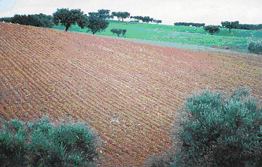
dry farming practices on marginally productive land g Description of reasons leading to inappropriate dry farming practices and why they are an issue in the context of desertification Author: Jorge García Gómez <jorgegg@um.es> Dry farming is becoming more and more marginal in Mediterranean Europe. This kind of agriculture is increasingly restricted to marginal lands while irrigated farming uses the most productive soils, the low lands, those with water available (except for the cases of enlargement of irrigation lands in traditionally dry farming areas, which occurs in some places). Dry farming practices are particularly important because land used for this kind of agriculture is extremely sensitive to the land management measures taken by farmers. Erosion and degradation processes are more rapid when inappropriate dry farming agricultural practices are applied, leading to desertification. Climatic conditions are one of the most important determining factors affecting agriculture, especially in the Mediterranean areas, with irregular rainfall and high summer temperatures. When it comes to dry farming these factors become even more important, because many farming practices have the objective of preparing the soil for the rainfall so that it can store as much water as possible. Soil conditions are derived from the original parent material and its development is due to many different factors including climatic conditions, fire, land uses, and agricultural practices. The loss of the thin layer of fertile soil makes degradation processes develop faster.
The reasons leading to inappropriate practices are closely related to social and economic changes in the rural areas. The low prices of dry farming products and competition from other countries make it increasingly difficult for farmers to maintain adequate incomes. Farmers then adopt different cultivation methods in order to obtain public subsidies or change to more profitable crops, even though the soil conditions may not be suitable. They might also decide to cultivate forest or hill slope areas, or simply resign. This process is favoured by the fragmentation of the land: while more land is necessary for a family to get enough income, land parcels become smaller and smaller because of the division of the land when passed from father to son, or when some parcels are sold. This leads to the new farmer treating farming as a secondary or a weekend activity, so putting much less effort into it, and sometimes not enough effort to maintain soil conditions or soil conservation practices. It is also necessary to mention the role that intensive grazing plays. In some areas (like the Guadalentín) livestock rearing is almost totally reduced to pig (or other) breeding in intensive husbandry systems such as stalls. However, in other areas intensive grazing puts a lot of pressure on pasture resources, finally leading to degradation problems when the vegetation cover is removed.
To fully understand this issue it is also necessary to consider the lack of information on best practices. The problem of erosion and desertification is not considered a priority by many politicians, so there is not enough effort made to raise knowledge levels in society. Even though there is a clear knowledge of the consequences of the problem there is only a diffuse knowledge about what the problem consists of and the reasons for it. If the perception of the problem is not very precise, the actions taken cannot be precise. In these fragile areas, not integrating measures to avoid degradation processes in the agricultural management of the land can be considered as an inappropriate practice. Why is it an issue? Inappropriate farming practices lead to soil and vegetation impoverishment. This impoverishment brings about a change in farm income, accelerated by the fact that dry farming is becoming less and less profitable in some areas, and can lead to land abandonment. When dry farming lands are abandoned they tend not to recover to their previous condition, but undergo rapid processes of erosion and degradation. g
Examples
of inappropriate farming practices in Mediterranean areas g
Lower Inner Alentejo, Portugal Although the soils of the Mértola municipality have an extremely low agricultural potential, their continued use for agriculture has persisted for a very long time and with significant spatial impact. Studies of land use change (Roxo 1994, Casimiro 2002) reveal that in certain periods of the nineteenth and twentieth century cattle breeding and cereal cropping were the main activities, alternating in dominance, for example with cereal production during the Wheat Campaign phases of the Estado Novo. Currently agricultural production is still based on the production of cereals and grazing, which is why these two activities and related techniques are described. Cereal cropping. The cultivation of cereals (wheat and oats) requires soil preparation. This task is carried out from September onwards when the first rains occur, when the machinery is able to work the soil. The high temperatures of the summer months and the absence of rainfall are responsible for the very hard surface crusting of the soil, which prevents seeding unless the soil is prepared first. The initial ploughing phase may occur in September but also during October or November, depending on the climatic characteristics of the year. This task is performed with a tractor, usually a disk tiller, and the cultivation direction is along the contours of the slope. Normally seeding takes place from the second week of November onwards, with the help of a line planter, a scarifier or a vibro to bury the seeds. Direct seeding is not used. Around 150 kg/ha of seeds are used. At the same time, nitrogen, phosphorus and calcium fertilizers are applied, roughly at about 150 kg/ha. In January more nitrogen fertilizer is applied, but only 120 kg/ha. Harvesting occurs from the third week of June onwards, but can occur earlier if the cereal spikes are dry. Rainfall ceases from late May to early June. The most used species of cereal are durum wheat and triticale. A good harvest averages at 2000 kg/ha, a bad one less than 1000 kg/ha. The crops are rotated the next year, usually with fallow or planted pasture.
Soil ploughing take place along the contours of the slope and emerging seedling cereals like wheat and oats do not provide good soil protection from November to March, when higher intensity rainfall events take place. These factors contribute to significant water erosion of the soil. Data obtained in the Vale Formoso Experimental Centre, located in the Mértola municipality, indicate soil loss rates higher than 2 tons/ha/year under wheat cropping. Cattle breeding. As a consequence of the soil and climate characteristics, cattle breeding uses natural and cultivated pastures, as well as leguminous crops for summer feeding. Nonetheless, it is important to mention that the basis of cattle feeding is still natural pastures, with straw from cereals. Climatic variability and incentives for cattle production have contributed to the increase in cultivated pasture area and legume (most commonly lupin) production. These two practices are described below.
Through the description of these agricultural practices, which are those most commonly used in the Alentejo, it becomes clear that some are better than others in their use of the soil resources. Therefore it is fundamental that farmers acquire knowledge and understanding leading to and allowing a reduction of soil fertility loss, and thus contributing to combating desertification. g
Guadalentin Basin, S. E. Spain Land use change
into irrigation farming: In some cases the solution that farmers adopt
consists of changing from dry farming to irrigation, even if the soil
conditions are not adequate for this intensification. Hillslope cultivation:
The cultivation of steep slope gradients makes erosion processes more
rapid. These areas are put into cultivation because farmers need more
income, or can claim EU subsidies. The erosion problem becomes more critical
when the tillage direction is not parallel but perpendicular to the contours,
because of harvesting techniques. Irrigation with
saline water: In some cases dry farming activities are intensified
by farmers who use irrigation. Water availability is a serious problem
in Mediterranean areas and in many cases the water quality is not good
for use in agriculture. Irrigation with high salinity water makes soil
degradation processes more rapid. Excessive tillage
operations: Some farmers consider that it is necessary to make as
many tillage operations as possible. Soils are ploughed in order to store
more water in the rainfall season but this makes the soil lose its vegetation
cover and facilitates soil loss. Intensive Grazing:
Uncontrolled grazing makes soil lose the protection that vegetation provides.
This vegetation impoverishment leads to a process of degradation of the
unprotected soil. Cultivation of forests (shrubs and trees): Forest lands in Mediterranean areas have a very sensitive balance, which can be broken easily. The cultivation of these areas of semi-natural shrub vegetation usually leads, after a short period, to farmers abandoning these areas and then degradation processes happen faster. Removal of vegetation cover: Farmers consider that the vegetation understorey competes with their crops for rain water, so they remove it when cultivating the soil. Fire: Some farmers burn the
stubble at the end of the growing season in order to prepare the soil
for the next. This, apart from the risk of creating uncontrolled fires,
has two negative consequences: biomass that could be incorporated into
the soil is lost, and the soil is left unprotected from erosion in heavy
rainfalls. g
Agri Basin, Italy The landscape of
the mountain and hilly areas of the Agri basin is a product of dry farming
practices and shares common issues with all the Mediterranean Areas. Organisational
systems of rural space, defined in the past by a delicate balance between
agricultural and pastoral activities, have become marginalised by processes
that can be seen both in economic and social demographic data. They are
areas characterized by strong depopulation, with a low population density
(for example the population density in Aliano and Craco is 1/6 lower than
the regional average). Population age structure, as well as generation
change, are showing negative trends reinforced by high unemployment indexes.
Agriculture is still the main activity in these areas and includes cereal cultivation (especially wheat) together with a progressive removal of areas of Mediterranean scrub and a continuous remodelling of the hillslope profiles to enable more efficient mechanization of cultivation operations.
The agricultural
systems are extremely simplified, based on cereals as the main crops with
only marginal interest in olive trees and the livestock sector (sheep
and goats). However the agricultural system is undergoing a process of
unavoidable reorganization because of lack of manpower. The spread of
wheat cultivation was favoured by different factors, firstly by EU subsides
that have modified the income from different cultures and secondly by
local policies that have allowed the creation of industrial areas in the
lower lands. The absorption of manpower into other economic sectors favoured
the cultivation of cereals that, because of mechanization, requires less
labour. With the entry into the EU of the PECO countries, food producers will experience very strong competitive pressure. The most dynamic component of the agricultural sector (in terms of its structural and income profile) is trying to react by giving added value to local products, relating them to the territory of provenance. The exchange of
information with stakeholders in the Agri conducted under the DESERTLINKS
project highlighted the fact that, in this area, there is a high perception
of the problems of soil degradation, as well as clear understanding of
its causes (deep, frequent ploughing, perpendicular to the contours; compacting;
calanchi levelling; Mediterranean scrub removal; stubble burning; absence
of rotation). Nevertheless, the adoption of good agricultural practice
is still missing and the knowledge transfer into farm management is very
low. Further investigation is required to discover which elements determine
practices chosen by local actors.
Some innovative farmers have introduced sod seeding practices for durum wheat, adapting the technology to the local context. Grass is not removed and there is less mechanical pressure on the soil. Water erosion phenomena (the most important degradation problem in the area) are reduced or avoided. g Lesvos,
Greece The island of Lesvos, covering an
area of 163,429 hectares, is located in the north-east part of the Aegean
sea. The western part of the island is already badly degraded and desertified,
while the rest is highly sensitive to desertification (Kosmas et al.,
2000(a); 2000(b)). The main land use types are olives, pine forests and
pastures covering 41.2%, 23.0% and 22.6% of the total area of the island
respectively. Oak forests and annual crops are limited, covering 7.1%
and 5.3%, respectively. Soil erosion due to terrace collapse and overgrazing,
and salinisation of lowland due to poorly drained soils and overexploitation
of ground water are the major processes of land degradation and desertification
in the area. Tending livestock is one of the main agricultural activities in the hilly areas of the western and central part of the island. Pastures are mainly located in hilly areas with shrubby vegetation (Sarcopoterium sp.), isolated deciduous oak and evergreen oak forests. Pastures are partially extended into pine forests but their quality is very low due to the limited understorey vegetation. Olive groves are grazed for two or three months during spring, after harvest by animals transported from other places. Today, a large number of animals (about 350,000) including sheep, goats, and cows are scattered throughout Lesvos, but most are in the central and western part. Land is overgrazed due to the large number of animals concentrated in that part of the land classified as pasture. The average number of animals per hectare ranges from 3.8 to 5.7 independent of the land characteristics. The amount of grass growing is not enough to satisfy the needs of the grazing animals. Therefore, farmers have to supply large amounts of animal feed, transported from other areas, in order to compensate the low productivity. Shepherds often damage natural vegetation by deliberately setting fires to eradicate vegetation and encourage the growth of new grass, which the animals then overgraze. The process of land degradation is greatly accelerated by high animal densities that lead to vegetation degradation and soil compaction. Several areas used today as pastures were previously cultivated, mainly with rainfed crops such as cereals, but due to low productivity the majority of sites were abandoned 40-45 years ago. After abandonment and migration of the local people to major towns, the land has been rented and used as pasture.
The other important agricultural activity on the island is the olive groves, covering an area of 60,966 hectares. Olive groves are mainly located in hilly areas and some in plain areas with relatively deep soils. The following three main management practices are applied: (a) no tillage-no pesticide application, (b) no tillage but with pesticide application, and (c) tillage with no pesticide application. Recently, the applications of pesticides and fertilizers have been greatly reduced due to the introduction of organic production of olive oil. The land is mainly cultivated with animal labour or small two-wheel tractors. Full mechanisation of cultivation is not easy due to steep slopes and the presence of narrow terraces restricting the use of heavy machinery. Inorganic fertilizers are applied in some fields in amounts ranging from 0.5 kg to 2.5 kg per tree. Hilly areas under olive groves (with
slopes usually greater than 6%) were terraced using stones several hundred
years ago. Individual crescentric terraces for individual trees or linear
terraces along the contour lines have been carefully constructed. The
soil was removed from other places to fill these terraces. If the terrace
collapses, the soil is immediately washed out, the consolidated parent
material is exposed on the surface, and the land is immediately degraded.
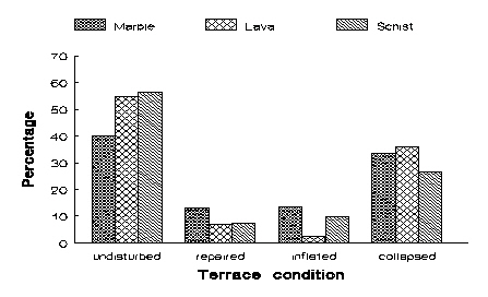
The conservation management practice of terracing the land requires high labour input to maintain the terraces. In recent decades, the value of such terraces has markedly declined due to: (a) difficulties associated with accessibility and use of machinery, (b) decreasing price of olive oil and increasing labour costs, and (c) extensive migration to mainland Greece. Detailed studies (Kosmas et al., 1998)
on terrace collapse showed that the stability of terraces is mainly related
to the slope gradient, soil type, stone composition and management practice.
Stones used for terrace construction have varying rates of weathering
and disintegration and therefore the rate of collapse is related to the
parent material. Terraces constructed from stones derived from lava and
schist have greater rate of collapse due to weathering. Terraces constructed
with stones originated from marble are the most stable. The frequency
of terrace collapse is greater in areas with soils formed on lava and
marble. This can be attributed to the stone origin as well as to other
factors, such as coefficient of linear extensibility (COLE) of the derived
soils.
The coefficient of linear extensibility (COLE) of the soil used for filling the terrace greatly affects its stability. If COLE is high, the horizontal pressure after soil wetting is high, especially at the base of the terrace, causing inflation, instability and finally terrace collapse. The highest values of COLE are found in soils formed on marl and ultrabasic rocks. The lowest values of COLE occur in soils formed on shale and volcanic lava.
Slope gradient also greatly affects terrace structure stability. Three critical slope classes can be distinguished: (a) less than 15%, (b) 15-35% and (c ) greater than 35%. Terraces constructed on slopes lower than 15% remain almost undisturbed under the prevailing management conditions in the area. The rate of collapse increases almost linearly with increasing slope gradient from 15% to 35%. The rate of collapse is very high on slopes greater than 35%.
Considering that terrace maintenance is absolutely necessary for land protection, olive groves can be classified into four categories based on their priority for maintenance. The classification is based on the following parameters: (a) slope gradient, (b) type of parent material, and (c ) COLE. Under these criteria the majority of the olive groves on Lesvos require immediate action for terrace protection. 32.6% of the olive groves require immediate action for terrace maintenance, and 44.3% are medium priority for maintenance. References
g Overview of how the indicators inter-relate
The framework for understanding the processes relating to inappropriate farming practices in dry lands includes soil, climatic and economic conditions and the land use type and intensity. Soil and climatic conditions (particularly in arid or semi-arid conditions), together with the land use, determine resources and farming practices, including grazing activities. For instance, Rainfall seasonality determines when and how the farmer prepares the soil to be able to store water. All these conditions together are responsible for the Net farm income. The soil and climatic conditions show the limits of the area in terms of resources and available uses. The land use type shows the potential earning that it is possible in that area and the farming practices that are necessary for a specific land use. The economic conditions, agricultural prices and EU subsidies are also essential to estimate the farm income, the real cornerstone in this issue. In low productivity areas, as in semi-arid Mediterranean areas, the EU production subsidies are highly important, sometimes becoming even more important than agricultural prices. This is because without these subsidies farmers would not be able to carry on with their activity. Because of this, EU subsidies are an important management factor in managing territories and combating desertification. Farm income is basic to understanding land management issues and farming practices affecting desertification in dry farming areas. Income sets the capacity of the farmer to invest in infrastructures and labour (including conservation practices) in the farm and has influence on the effort that he is willing to make. Farmers try to maximise their farm income, so they direct production to those products that can provide better prices or assured income (such as from subsidies). Hence the area under subsidy can also explain many of the changes in cropping regime and therefore in the cultivation practices. Sometimes (and more and more often in many dry lands) farming becomes increasingly difficult and the farm income is not enough to assure the subsistence of farmers and their family. Then, Parallel employment is necessary. This parallel employment assures some incomes for the farmer but also affects land management, since less time and effort is available for farming activities. On the other hand, there are other circumstances, socio-economic conditions, which put pressure on the land uses:
All these conditions help us to understand land management issues, since they put pressure on farmer's decisions and become driving forces for the land management changes:
As a result of a negative combination of all these land management changes, soil degradation processes can start. This can be produced not only by land abandonment but also in cultivated parcels where insufficient conservation measures are made, resulting in desertification processes. Actions to combat desertification should not be delayed until desertification processes have started, because then solutions are more difficult, more expensive and less effective. Responses must focus on the land management issues and on the socio-economic conditions of the farmers. Only by ensuring that farmers carrying on farming, and that conservation measures are included in the land management issues and that the Land use evolution is not directed to unsustainable uses, will combating desertification be a success. Policy enforcement, which must include the regulation and support of agro-environmental management practices and socio-economic actions (like redirecting subsidies or support to the rural inhabitants), is the key to combating desertification in dry farming areas. |
|||||||||||||||||||||||||||