English-EN | Español-ES | Italiano-I | Ελληνικά-GR | Portuguese-PT
| |
DIS4ME | DIS4ME
Homepage | DESERTLINKS Homepage
| © DESERTLINKS 2004 English-EN | Español-ES | Italiano-I | Ελληνικά-GR | Portuguese-PT |
| Desertification Indicator System for Mediterranean Europe | ||
|
Changes in the social structure Lead authors: Giovanni Quaranta, Rosanna Salvia, Monica Caggiano <quaranta@unibas.it> With contributions from: Maria José Roxo and Pedro Cortesao Casimiro <mj.roxo@iol.pt>, Jorge García Gómez <jorgegg@um.es>, Giovanni Quaranta, Rosanna Salvia <quaranta@unibas.it> g Description of reasons for changes in the social structure and why these are an issue in the context of desertification Changes in the social structure are both a cause and an effect of degradation of the land. These conditions lead to a downward spiral of weakening social capital and land degradation. There is, in fact, a strong interdependence between poverty and degradation of natural resources. Poverty is, in this context, a multidimensional phenomenon, characterized by a multitude of factors such as a deficiency in the enjoyment of human rights, a lack of sufficient income, a lack of power (i.e. lack of information, knowledge, participation in the political decision process), a lack of social integration and a lack of access to social services. Changes in the social structure occur frequently due to the fact that the local socio-economic context has become incapable of satisfying the population's needs. This may be as a consequence of the degradation to which man has subjected the landscape over time, or due to the fact that the poverty of the resources has not produced the necessary and adequate interest by economic and social actors. When problems arise, such areas are left totally abandoned, deprived of the conditions that might mitigate the problem, for example by encouraging the use of good management practices to avoid destructive phenomena as fire or landslides. The rapid and intense depopulation experienced means that the population in such areas is not just reduced in number but also ageing fast. These factors discourage decision-makers from applying measures in those regions, accentuating the tendency towards increasingly serious depopulation. At the other extreme, the people who abandon rural areas move into the cities, especially on the coastal strip, creating enormous pressure on these areas in both demographic and environmental terms. Migration is a selective process of the more productive and highly educated members of the community, leading to labour shortages and lack of management of natural resources in the rural landscape. Terraces and other labour-intensive anti-erosion structures may not be properly maintained, leading to further land and water degradation. It is widely recognized, for example, that rural viability relates to issues such as farmer age structures, as well as educational and managerial skills, and access to key services. The entry into agriculture of young farmers can provide some indication of the potential long-term viability of agriculture, given that a younger workforce is more likely to be able to respond rapidly to changing economic and environmental conditions. They are more likely to understand about the sustainability of agriculture (OECD, 2001) and can be encouraged to invest in soil conservation measures or make long-term investments in its improvement. g
Examples of reasons for social changes in Mediterranean
areas g
Lower
Inner Alentejo, Portugal The total population resident in the Mértola municipality is 8,700 inhabitants, representing 6.4 % of the Lower Alentejo (NUT III) population, and corresponding to a population density of 6.7 Inhab/km². This area may be characterised generically by poor demographic dynamics and potential, translating to a generalised and progressive loss of population over recent decades, especially since the 1950s. Migration is the most dominant feature of demographic behaviour in this area. This has resulted in an unbalanced population structure, with mainly older people, in the Alentejo. It is reflected too in the degree of occupation of housing, leading to clear under-occupation of the housing stock (see the description given in the Land Abandonment issue). To this demographic picture a social situation has to be added with relatively poor status of quality of life and poor levels of comfort indicators for housing and health.
The most recent demographic projections, carried out at regional scale, do not point to an improvement in the situation in this area, even considering the future impacts of enterprises like the Alqueva dam (providing a source of water for irrigation). Certainly the dam will have some positive effect, but most specifically in areas close to the boundary of possible irrigation, while the position of the Mértola municipality makes it peripheral and marginal to all these activities.
In the face of this scenario, it becomes essential to incentivize and support investment in areas and activities complementary to agriculture, as well as in the use and profitability of the endogenous resources (natural and cultural), with the goal of developing activities able to maintain the younger population and enterprises. However these activities must take account of the fragility of the natural resources of the area of the Inner Lower Alentejo, and contribute to preserving the identity of the region. g Spain Changes in the social structure in the Guadalentín basin are more related to change in the economic activities than to land degradation. The enlargement of irrigation (sometimes changing land use from dry farming to irrigation farming), the building sector and tourist developments have changed the economic framework of the area, and have moved them to the coast. This change in economic activities is accompanied by changes in the population, in two different senses:
These factors have changed social
structures. In the inner areas a less dynamic, aged population, is the
main characteristic. In coastal areas economic activities increases, farming
is replaced with tourist developments and the population increases. Also
migration from the U.K. and Germany is changing the social structure.
There are many retired people seeking cheaper prices and a better quality
of life. This new social group is often detached from the rest of the
society because they are reluctant to integrate and do not learn to speak
Spanish. g
Agri
Basin, Italy
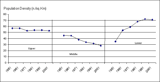
The most widespread manifestation of the cause-effect issue for desertification in Val d'Agri is depopulation. The whole Agri Basin, in fact, has a density of 45 inhabitants per square kilometre; this value remains much lower than both the Italian average (190) and the value for the Basilicata region (65). At a sub area level the situation is definitely different: while the number of residents has decreased in the middle Agri, bringing the density index down to 28 inhabitants per square kilometre, it has increased in the lower part to a density of 72 inhabitants per square kilometre.
Migration also occurs across the sub
areas: people move from the mountains to the valleys, where the main infrastructures
are, such as motorways, provincial and local administration offices and
other public and private services. In contrast, the populations of many
villages on the surrounding hills and mountains are slowly but unmistakably
decreasing.
In the lower Agri basin, and along the coast, the intensification of agriculture and the development of tourism have made the area more and more attractive, and have led to a demographic increase. Demographic shortfall and depopulation are a serious issue for a large part of the basin, especially because migration is mainly of the younger and more literate part of the population. This process is partially due to the increasing problem of isolation, both physical and cultural, which is considered to be a main constraint of the Agri basin. According to the 2000 general census,
the island of Lesvos has 110.938 people. The distribution of population
in the regions of Mythimna, Mytilini and Plomari is 23,042, 81,054, and
6,842 respectively. Therefore, 61% of the total population of the island
is concentrated in the region of Mytilini. The population of Mythimna
and Plomari regions are undergoing a continuous decrease mainly due to
migration to urban areas, including Mytilini. The local population in
the region of Mytilini decreased between 1955 and 1970 after this period
the population remained almost unchanged. The changes in the local population of Mythimna and Plomari regions are attributed to different reasons. In the region of Mythimna the land is highly degraded due to past misuse and adverse climatic conditions (less rainfall, strong winds) compared to the other regions. More than half of the land (53%) has been classified as critical to desertification characterised by low productivity. Moreover, as the income of the farmers is low and the living conditions in the area are adverse, migration to urban areas is high and has become a major issue. The low population densities in the region of Mythimna compared to the other regions can be attributed the poor land conditions present in this region. The density of people per hectare has change from 0.52 in 1940 to 0.28 in 2001, while in the regions of Plomari and Mytilini the population density per hectare changed from 1.07 to 0.87 and from 1.26 to 0.50, respectively, for the same period.
Even though the majority of the land
in the region of Plomari is characterized as fragile (70% of this area),
population density has continuously decreased from 1.26 in 1940 to 0.50
people/ha in 2000. The decrease in population cannot be attributed only
to land conditions as in Mythimna but to the decline of olive oil and
soap industry in the last decades. Therefore, changes in population cannot
be considered only in association to land degradation and land productivity. The island of Lesvos has been significantly
affected by tourism especially in the last two decades. The number of
tourist stays in Lesvos has increased from 96,122 in 1970 to 345,689 in
1998. The corresponding density of tourists per hectare has changed from
0.59 in 1970 to 2.12 in 1998. The change in tourists has affected both
the conditions of living of the local people and the use of the natural
resources of the island. Agricultural land is now converted to urban land
especially along the seashore. A large pressure is exerted on ground water
resources due to continuously increased demands for water consumption.
The over-exploitation of aquifers is expected to reduce the amount and
the quality of water allocated to the agriculture with adverse consequences
to the low land areas which are irrigated. g Overview of how the indicators inter-relate
The changing agricultural system and the availability of opportunities outside the agricultural sector strongly affect the social structure and its dynamics. The tendency toward greater concentration in production has led to the replacement of mixed farming by more specialised enterprises (i.e. livestock or arable based farms) not only at the individual farm level but also for whole regions (OECD, 2001). On the other hand, the agricultural marginalisation phenomenon from the field to the regional scale has to be considered. Regions with small-scale agriculture are especially vulnerable, and abandonment can have serious consequences for the natural environment. The response possibilities rely on the capacity of the farms to convert towards more profitable products or to a better integration with the off-farm social-economic context. As an extreme consequence, marginal lands and those much more distant from the farm centre, can be progressively abandoned. Moreover the distance reduces the "supervision" of the land and the maintenance of the landscape. Arable land and water resources are often used in an intensive manner, indicating a level of conversion of land to high input agriculture. Availability of irrigation water is linked to other intensification processes with potentially negative effects on sustainability, such as monoculture, selection of high yielding varieties in detriment to genetic diversity, runoff and soil erosion, compaction, and salinization, that lead to acceleration of desertification processes. Monitoring of changes in water scarcity is crucial in the arid and semi-arid regions, where the water cycle is discontinuous. As a result, in the desertification-sensitive areas there is a deficit between the locally available water and the consumption needs. This deficit is growing as consumption increases, while available resources do not increase. The integration of the family members in the external labour market can be seen as a tool to avoid the negative interdependence between poverty and degradation of natural resources in marginal areas. Many studies conducted in poor rural areas show that agricultural activity, when it is the only source of income for the family, is substantially like a kind of continuous "robbery" that accentuates the environmental degradation already broadly diffused in these areas. The off-farm labour opportunities provide the possibility of remaining on the land, and better guarantees for controlling the territory in terms of resource preservation. The farm income plays a very important role in defining the strategies for farmers with respect to the land. If the farmers get enough production from the farm, then they will adopt all the possible strategies to preserve the soils, not only to safeguard the environment (from the social point of view) and patrimony (from a private point of view) but also as an important income source. The impact of the Common Agricultural Policy has operated through its price and structural policies. Price support has ensured an adequate income to farmers, and thus contributed to the development of regional economies and the maintenance of landscapes especially in less favoured areas. However, the price support under the Common Agricultural Policy also accelerates the intensification and specialisation process in Europe. Higher farm prices under the CAP encourage farmers to produce more, which, given the limited land base in Europe, implies greater intensification and use of non-land inputs. Differences in protection rates under the CAP tend to favour more environmentally marginal crops. Imbalances in protection have also been responsible for the growth in intensive animal husbandry. The viability of rural life relates to issues such as farmer age structure, besides educational and managerial skills and access to key services. The entry into agriculture of young farmers can provide some indication of the potential long-term viability of agriculture, given that a younger workforce is more likely to be able to respond rapidly to changing economic and environmental conditions and the sustainability of agriculture (OECD, 2001). Farm ownership is also crucial. Farmers, if they do not have a long-term perspective on the property of the land, are not encouraged to invest in soil conservation measures or make long-term investments in its improvement. The vitality of the labour market is an important driving force in defining the territory abandonment processes. It can be seen as a tool to avoid the negative interdependence in marginal areas, between poverty and desertification processes, conditioning the economic capacity to implement measures to combat desertification. Tourism is one of the most important social and economic activities in Europe and is linked to desertification processes. It has grown by almost 5% per annum since the early 1970s, although there is a growing recognition that at many tourist destinations, traditional management practices have led to undesirable social and environmental impacts, also contributing to land degradation processes. The consequences of the changes in the social structure can be identified in the modification of the demographic dynamics, in accentuation of phenomena such as littoralisation and urbanization that lead to changes in the land use. The rate of population growth is identified by Agenda 21 as one of the crucial elements affecting long-term sustainability, impacting on land degradation in different ways. However, rapid population growth can place a strain on a country's capacity for handling a wide range of issues of economic, social, and environmental significance, particularly when rapid population growth occurs in conjunction with poverty and lack of access to resources, or unsustainable patterns of production and consumption, or in ecologically vulnerable zones. Especially in the Mediterranean basin, depopulation can also negatively impact and accelerate land degradation processes, when it leads a decrease of land protection. The relationship between population growth and desertification must therefore be analysed in relation to other factors affecting sustainability for each area. One of the major causes of loss of environmental resources in the Mediterranean basin is urban sprawl, the uncontrolled expansion of urban settlements onto semi-natural and agricultural areas along the coast. The analysis of the socio-economic context in which urban sprawl occurs is essential in order to define strategies to control and mitigate the process. It is essential to draw up, implement and map development and land use management plans The current land use type and the period of existence of the land use type is important as it is related to cumulative long-term effects on land protection or on land degradation. The extensive deforestation of hilly areas and intensive cultivation with rainfed crops such as cereals, almonds, vines, and olives in the Mediterranean has already led to various degrees of soil erosion and degradation in the last century. The stage of land degradation depends on the type and the period of existence of land use type. For example, hilly areas which were under forest with deep soils were brought into cultivation for cereals or olives. Under the prevailing management practices the erosion rates in areas with cereals are higher than in olive groves. Today several areas cultivated with cereals for decades or centuries have become highly degraded and then abandoned due to low land productivity. The loss in land productivity soon becomes apparent in areas with soils having limiting subsurface layers, such as petrocalcic horizons or bedrock. Under sustained erosion the soil depth is drastically reduced and under hot and dry climatic conditions such areas are desertified. However, areas cultivated with olives under similar soils, topographic, and climatic conditions are better protected from degradation and desertification for longer periods than areas cultivated with cereals. Vegetation and land use are clearly important factors controlling desertification processes such as fire risk and the ability of vegetation to recover, erosion protection offered to the soil, and drought resistance. The dominant biotic land component in terms of desertification is the vegetative cover as it controls water run-off generation. Other processes strongly affect vegetation cover. Forest fire is one of the most important causes of land degradation in hilly areas of the Mediterranean region. The various plant species react to fire in different ways. Forest fires occur frequently in pine-dominated forests with adverse consequences for soil erosion and biodiversity loss. The frequency of fire occurrence is lower in grasslands, and mixed Mediterranean macchia with evergreen forests. The type of vegetation and vegetation cover controls intensity and the frequency of overland flow and surface wash erosion. Areas cultivated with rainfed crops such as cereals, vines, and almonds become vulnerable to erosion and desertification because of the decreased protection by vegetation cover in reducing effective rainfall intensity at the ground surface. Soil erosion experimental data collected under existing management practices in the Mediterranean region have shown that some the prevailing land use types can be graded in order of decreasing effect on soil erosion as following: vines > eucalyptus > winter wheat >shrub land > olives. The various ecosystems present various degrees of adaptation and resistance to aridity. Under severe drought, the plant leaf area index is reduced, resulting in an increase of the probability of enhanced soil erosion as protective vegetation cover is reduced.
|
|||||||||||||||||