You are here
Gully Erosion
Gully erosion is the formation and subsequent expansion of erosional channels in the soil as a result of concentrated water flow. Gully dimensions can vary over several orders of magnitudes. Conventionally a gully is distinguished from a rill based on a critical cross-sectional area of at least one square foot, i.e. the size of a channel that can no longer be erased via normal tillage operations. Gullies are often associated with a wide range of on-site and off-site impacts. On-site impacts include the direct loss of land, trees and crops as well as reduced trafficability. These limit opportunities for agriculture and other land uses. Gullies can also cause significant damage to roads, buildings and other infrastructure. In severe cases, such destructions may claim significant numbers of casualties. Potential off-site impacts of gully erosion include changes in catchment hydrology, such as lower river baseflows and higher peak runoff discharge. Gullies can indirectly contribute to sediment loads by increasing the runoff and sediment connectivity between upland areas, valley bottoms and river networks or lakes. As such, gully erosion is a great concern in many regions worldwide. It is a key process of land degradation and desertification , posing a significant threat to various ecosystems and ecosystem services.
Given these impacts and concerns, land use and catchment management strategies are needed that allow the prevention and mitigation of gully erosion and its impacts. Controlling gully erosion is often complex and costly and typically requires a catchment-wide approach. Conventional erosion control measures aimed at reducing sheet and rill erosion on hillslopes are often insufficient and specific interventions, such as the installation of check dams or revegetation within the gully channel, are often required. Successfully implementing such measures is usually very challenging, due to their risk of failure, their need for maintenance, feedback mechanisms like the ‘clear water’ effect, but also their often high associated costs.
Nevertheless, it is worth noting that gullies can sometimes also create interesting opportunities and positive outcomes. When well managed, they can become productive and biodiverse hotspots that play a key role as ecological corridors. Gullies are generally seen by the scientific community as a key landform to understand the environmental change and soil erosion risks and they can play an important role in raising general awareness about these issues. Given their great visibility they can also help in raising awareness on erosion problems. Because of their often great esthetical value or spectacular nature, several gullied areas and badlands even have large potential as geoheritage sites.
A working group of several scientists met for the Gully Erosion workshop , March 2018 in Ispra, Italy. The workshop was orgnanised by the Joint Research Centre (JRC) and the outcome of this workshop is the following review:
Vanmaercke, M., Panagos, P., Vanwalleghem, T., Hayas, A., Foerster, S., Borrelli, P., Rossi, M., Torri, D., Casali, J., Borselli, L., Vigiak, O., Maerker, M, Haregeweyn, N., De Geeter, S., Zgłobicki, W., Bielders, C., Cerda, A., Conoscenti, C., de Figueiredo, T., Evans, B., Golosov, V., Ionita, I., Karydas, C., Kertesz, A., Krasa, J. Le Bouteiller, C., Radoane, M., Ristic, R., Rousseva, S. Stankoviansky, M., Stolte, J. Stolz, C., Bartley, R., Wilkinson, S., Jarihani, B. Poesen, J. 2021. Measuring, modelling and managing gully erosion at large scales: A state of the art. Earth-Science Reviews, DOI: 10.1016/j.earscirev.2021.103637, p.103637.
Assessing gully erosion through monitoring Observations on the occurrence of gullies, their dimensions and their dynamics are essential to quantify gully erosion rates, to identify the factors that control them and to develop and evaluate predictive models. Monitoring the occurrence and dynamics of gully systems remains essential for better understanding and constraining rates and controlling factors of gully erosion. Especially datasets on the initiation and evolution of gully systems over large areas are a prerequisite for the development of models that can simulate this process at larger scales. Such datasets currently remain scarce. New remote sensing products can greatly help in addressing this gap. Nevertheless, monitoring gully erosion at larger scales remains highly labour-intensive and/or requires significant concessions in accuracy, completeness and level of detail. Also the limited length of the observation periods and the coarse temporal resolution often form important constraints. We make the following recommendations with respect to gully monitoring via remote sensing:
|  |
Modelling Gully Erosion in the EU with LUCAS The LUCAS 2022 survey extended the visual detection of gully erosion channels to all 399,591 locations of the monitoring grid across the EU. The survey focused on gully channels. LUCAS feature detection 2022 surveyed 399,591 locations through in situ (49.8%) and on-screen (50.2%) observations. Here we a predictive interpolation of the gully erosion channels probability across the EU and the U.K. In addition, point data with gully occurence (and pictures) are also available.Data are available here together with the scientific publication: Borrelli, P., Matthews, F., Alewell, C., Kaffas, K., Poesen, J., Saggau, P., Prăvălie, R., Vanmaercke, M., Panagos, P. 2025. A hybrid in situ and on-screen survey to monitor gully erosion across the European Union. Nature Scientific Data 12, 755 | 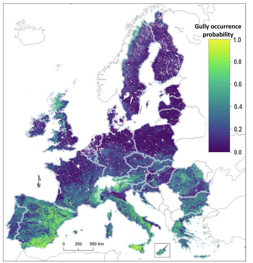 |
Measurements on gully erosion in Europe: an overview Overall, gully erosion mainly received significant field-based research attention in some particular countries, i.e. Belgium, Germany, Italy, Spain, Romania and the UK. Most studies investigated permanent gullies in forests or rangelands. Relatively fewer studies report on ephemeral gullies, which are typically observed after erosive periods in cropland. Most studies focused on a single gully channel or on a limited number of selected gullies in a particular study area. However, a few studies provide gully inventories for extensive areas (> 10,000 km2) or even entire countries: Slovakia, Poland, East Romania, Northern France, Middle Volga and Hungary.
|  |
Gully erosion models Predicting gully erosion rates and its impact on sediment loads encompasses several challenges. These include predicting: (i) where and why gullies occur, (ii) when and how these gullies expand, and (iii) to what extent these gullies contribute to catchment sediment yields. Numerous gully erosion models have been developed. However, no single model presently exists that addresses these three components. Furthermore, most modelling efforts have concentrated on individual gullies or local scales.
|  |
|
|
Title: Global patterns of gully occurrence | |
|
Resource Type: Datasets, Soil Threats Data Theme/Sub-Theme: Gully Erosion |
Continent: Year: 2026 Keywords: Gully |
|
|
|
||
 |
Title: Gully erosion in the EU | |
|
Resource Type: Datasets, Soil Threats Data Theme/Sub-Theme: Gully Erosion Registration requested: Request Form |
Continent: Year: 2025 Keywords: Gully |
|
|
|
||
 |
Title: Gully Erosion based on LUCAS | |
|
Resource Type: Datasets, Soil Threats Data Theme/Sub-Theme: Gully Erosion |
Continent: Year: 2022 |
|
|
|
||