You are here
European Landslide Expert Group
The European Landslide Expert Group was created by the Institute for Environment and Sustainability of the JRC in 2007 to carry out collaborative research in support of European Union soil policy making concerning landslides.
Members
(the persons hereunder agreed to have their name and email listed on this ESDAC website)
- José Chacón, University of Granada, Spain
- Claire Dashwood, British Geological Survey (BGS), Keyworth, Nottingham, UK
- Andreas Günther, Federal Institute for Geosciences and Natural Resources (BGR), Hannover, Germany
- Javier Hervas, Panos Panagos (coordinator), Joint Research Centre (JRC), European Commission, Ispra, Italy
- Peter Hobbs, British Geological Survey (BGS), Keyworth, Nottingham, UK
- Jean-Philippe Malet, Institute of Physics of the Globe (CNRS-EOST), Strasbourg, France
- Alessandro Pasuto, Research Institute for Hydrogeological Protection (CNR-IRPI), Padua, Italy
- Eleftheria Poyiadji, Institute of Geology and Mineral Exploration of Greece (IGME), Acharnae, Greece
- Paola Reichenbach, Research Institute for Hydrogeological Protection (CNR-IRPI), Perugia, Italy
- Sebastiano Trevisani, IUAV University, Venice, Italy (formerly with the Research Institute for Hydrogeological Protection, CNR-IRPI, Padua, Italy)
Activities
The European Landslide Expert Group has produced guidelines for delineating areas at risk of landslides in Europe using harmonised approaches and common thematic datasets, as suggested by the EU Thematic Strategy for Soil Protection and the related Proposal for a Soil Framework Directive. Such approaches initially focus on landslide susceptibility mapping and are based on Tiers. These consist of hierarchically-ordered, geographically-nested approaches whereby areas identified as of high susceptibility to landslides in the initial, synoptic-scale Tier (Tier 1) are subsequently evaluated and mapped at higher resolution in successive Tiers.
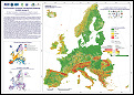
The Group has additionally developed models for landslide susceptibility assessment at European scale (Tier 1) and national scales (Tier 1 and 2) using available landslide conditioning factor datasets and landslide inventory data. As a result, landslide susceptibility maps have been produced for Italy and France, as well as a first version of the European Landslide Susceptibility Map (ELSUS1000 v1), released on 15 February 2013, and a second version (ELSUS v2) on 12 February 2018 (see Data and Publications sections below).
Current work focuses on (1) evaluating the accuracy of ELSUS v2; (2) testing statistical approaches for landslide susceptibility assessment in selected areas of Europe where landslide inventory data are more complete; and (3) assessing landslide susceptibility at pan-European and national scales in selected countries separately for major landslide types. These activities are carried out in collaboration with some members of the European Centre on Geomorphological Hazards (CERG) and of EuroGeoSurveys’ Earth Observation and Geohazards Expert Group, as well as with other European landslide experts.
.
Data
To get access to the new European Landslide Susceptibility Map ELSUS v2, including ancillary spatial datasets and metadata, please compile the Request form; instructions on how to download the data will then follow.
Please note that ELSUS v2 shows larger geographical coverage, higher spatial resolution and higher prediction model performance than the former version ELSUS1000 v1. The latter has been removed from ESDAC following publication of ELSUS v2.
Publications
- Wilde, M., Günther, A., Reichenbach, P., Malet, J.-P., Hervás, J., 2018. Pan-European landslide susceptibility mapping: ELSUS Version 2. Journal of Maps, 14(2), 97-104 and supplemental map.
- Hervás, J., 2017. El inventario de movimientos de ladera de España ALISSA: Metodología y análisis preliminar. In: Alonso, E., Corominas, J., Hürlimann, M. (Eds.), Taludes 2017. Proc. IX Simposio Nacional sobre Taludes y Laderas Inestables, Santander, 27-30 June 2017. CIMNE, Barcelona, pp. 629-639.
- Hervás, J., 2016. Elaboración de inventarios nacionales de movimientos de ladera en España y Chipre para la evaluación de su susceptibilidad a escalas nacional y europea. In: Durán, J.J., Montes, M., Robador, A., Salazar, A. (Eds.), Comprendiendo el relieve: del pasado al futuro. Proc. XIV Reunión Nacional de Geomorfología, Málaga, 22-25 June 2016. IGME, Madrid, pp. 237-242. (In Spanish with English abstract)
- Günther, A., Wilde, M., Malet, J.-P., Reichenbach, P., Hervás, J., 2015. Improvements in pan-European landslide susceptibility assessment: the ELSUS version 2 map. Geological Society of America Abstracts with Programs, Vol. 47, No. 7, pp. 549.
- Hervás, J., 2015. New national landslide inventories of Spain, Cyprus and Andorra for pan-European landslide susceptibility assessment. Geological Society of America Abstracts with Programs, Vol. 47, No. 7, pp. 249.
- Wilde, M., Günther, A., Malet, J.-P., Reichenbach, P., Hervás, J., 2015. Update of the European Landslide Susceptibility Map (ELSUS Version 2). Geophysical Research Abstracts, Vol. 17, EGU2015-12281-1.
- Günther, A., Van Den Eeckhaut, M., Malet, J.-P., Reichenbach, P., Hervás, J., 2014. Climate-physiographically differentiated Pan-European landslide susceptibility assessment using spatial multi-criteria evaluation and transnational landslide information. Geomorphology, 224: 69-85
- Günther, A., Hervás, J., Van Den Eeckhaut, M., Malet, J.-P., Reichenbach, P., 2014. Synoptic pan-European landslide susceptibility assessment: The ELSUS 1000 v1 map. In: Sassa, K., Canuti, P., Yin, Y. (Eds.), Landslide Science for a Safer Geoenvironment. Springer, Switzerland, Vol. 1, pp, 117-122.
- Hervás, J., 2014. ALISSA: Abridged Landslide Inventory of Spain for synoptic Susceptibility Assessment. Geophysical Research Abstracts, Vol. 16, EGU2014-1805.
- Günther, A., Van Den Eeckhaut, M., Malet, J.-P., Reichenbach, P., Hervás, J., 2013. The European landslide susceptibility map ELSUS 1000 Version 1. Geophysical Research Abstracts, Vol. 15, EGU2013-10071.
- Günther, A., Reichenbach, P., Malet, J.-P., Van Den Eeckhaut, M., Hervás, J., Dashwood, C., Guzzetti, F., 2013. Tier-based approaches for landslide susceptibility assessment in Europe. Landslides 10: 529-546.
- Hervás, J., Van Den Eeckhaut, M., Günther, A., Malet, J.-P., Reichenbach, P., 2013. Towards a common approach to identify landslide risk areas in Europe in the context of EU policies: First developments. In: Zamariolo, A. (Ed.) Proceedings Coast Expo and Esonda 2013. Ferrara, Italy, 18-20 September 2013. Ferrara Fiere Congressi
- Van Den Eeckhaut, M., Poesen, J., Günther, A., Malet, J.P., Reichenbach, P., Guzzetti, F., Hervás, J., 2012. State-of-the-art and challenges of landslide susceptibility modelling at regional to continental scales. Proc. 32nd International Geographical Congress, 26-30 August 2012, Cologne, Germany, pp. 758.
- Günther, A., Van Den Eeckhaut, M., Reichenbach, P., Hervás, J., Malet, J.-P., Guzzetti, F., 2011. Continental level landslide susceptibility assessment in the context of the European Union's Soil Thematic Strategy. Abstract Proc. AGU Fall Meeting 2011, San Francisco, USA, 5-9 December 2011, NH11B-08.
- Günther, A., Van Den Eeckhaut, M., Reichenbach, P., Hervás, J., Malet, J.-P., Foster, C., Guzzetti, F., 2013. New developments in harmonized landslide susceptibility mapping over Europe in the framework of the European Soil Thematic Strategy. In: Margottini, C., Canuti, P., Sassa, K. (Eds.), Landslide Science and Practice (Proc. Second World Landslide Forum, 3-7 October 2011, Rome), Springer, Heidelberg, Vol. 1, pp. 297-301.
- Malet, J.-P., Puissant, A., Alexandre, M., Mathieu, A., Van Den Eeckhaut, M., Fressard, M., 2013. Integrating spatial multi-criteria evaluation and expert knowledge for national-scale landslide susceptibility analysis: application to France. In: Margottini, C., Canuti, P., Sassa, K. (Eds.), Landslide Science and Practice (Proc. Second World Landslide Forum, 3-7 October 2011, Rome), Springer, Heidelberg, Vol. 1, pp. 303-311.
- Hervás, J., Günther, A., Reichenbach, P., Malet, J.-P., Van Den Eeckhaut, M., 2010. Harmonised approaches for landslide susceptibility mapping in Europe. In: Malet, J.-P., Glade, T., Casagli, N. (Eds.), Proc. Int. Conference Mountain Risks: Bringing Science to Society, Florence, Italy, 24-26 November 2010. CERG Editions, Strasbourg, pp. 501-505.
- Günther, A., Hervás, J., Reichenbach, P., Malet, J.-P., 2010. Progress in landslide susceptibility mapping over Europe using Tier-based approaches. Geophysical Research Abstracts, 12, EGU2010-15275.
- Malet, J.-P., Thiery, Y., Puissant, A., Hervás, J., Günther, A., Grandjean, G., 2009. Landslide susceptibility mapping at 1:1M scale over France: exploratory results with a heuristic model. In: Malet, J.-P., Remaître, A., Boogard, T. (Eds), Proc. International Conference on Landslide Processes: from Geomorphologic Mapping to Dynamic Modelling, 6 -7 February 2009, Strasbourg, France. CERG Editions, Strasbourg, pp. 315-320.
- Malet, J.-P., Thiery, Y., Puissant, A., Hervás, J., Guenther, A., Grandjean, G., 2009. Landslide susceptibility mapping at 1:1M scale over France. Geophysical Research Abstracts, 11, EGU2009-3274.
- Günther, A., Reichenbach, P., Hervás, J., 2008. Approaches for Delineating Areas Susceptible to Landslides in the Framework of the European Soil Thematic Strategy. Proceedings of the First World Landslide Forum, Tokyo, 18-21 November 2008, pp. 235-238.
- Hervás, J., Günther, A., Reichenbach, P., Guzzetti, F., Chacón, J., Pasuto, A., Trigila, A., Malet, J.-P., Tagliavini, F., 2008. Towards a common approach for mapping areas susceptible to landslides in Europe. Geophysical Research Abstracts, 10, EGU2008-A-12200.
- Hervás, J. (Ed.), 2007. Guidelines for Mapping Areas at Risk of Landslides in Europe. Proc. Experts Meeting, JRC, Ispra, Italy, 23-24 October 2007. JRC Report EUR 23093 EN, Office for Official Publications of the European Communities, Luxembourg, 53 pp.
- Günther, A., Reichenbach, P., Guzzetti, F., Richter, A., 2007. Criteria for the identification of landslide risk areas in Europe: the Tier 1 approach. In: Hervás, J. (Ed.), Guidelines for Mapping Areas at Risk of Landslides in Europe. Proc. Experts Meeting, Ispra, Italy, 23-24 October 2007. JRC Report EUR 23093 EN, Office for Official Publications of the European Communities, Luxembourg, pp. 37-39.
- Hervás, J., Günther, A., Reichenbach, P., Chacón, J., Pasuto, A., Malet, J.-P., Trigila. A., Hobbs, P., Maquaire, O., Tagliavini, F., Poyiadji, E., Guerrieri, L., Montanarella, L., 2007. Recommendations on a common approach for mapping areas at risk of landslides in Europe. In: Hervás, J. (Ed.), Guidelines for Mapping Areas at Risk of Landslides in Europe. Proc. Experts Meeting, Ispra, Italy, 23-24 October 2007. JRC Report EUR 23093 EN, Office for Official Publications of the European Communities, Luxembourg, pp. 45-49.
- Reichenbach, P., Günther, A., Guzzetti, F., 2007. Criteria for the identification of landslide risk areas in Europe: the Tier 2 approach. In: Hervás, J. (Ed.), Guidelines for Mapping Areas at Risk of Landslides in Europe. Proc. Experts Meeting, Ispra, Italy, 23-24 October 2007. JRC Report EUR 23093 EN, Office for Official Publications of the European Communities, Luxembourg, pp. 41-44.
- Panagos, P., Van Liedekerke, M., Jones, A., 2007. Pan-European soil databases. In: Hervás, J. (Ed.), Guidelines for Mapping Areas at Risk of Landslides in Europe. Proc. Experts Meeting, Ispra, Italy, 23-24 October 2007. JRC Report EUR 23093 EN, Office for Official Publications of the European Communities, Luxembourg, pp. 3-6.
- Hervás, J., Montanarella, L., 2007. Main issues on landslide mapping harmonisation in EU Member States in the framework of European Commission soil policy. In: Hervás, J. (Ed.), Guidelines for Mapping Areas at Risk of Landslides in Europe. Proc. Experts Meeting, Ispra, Italy, 23-24 October 2007. JRC Report EUR 23093 EN, Office for Official Publications of the European Communities, Luxembourg, pp. 7-10.
- Hobbs, P., 2007. BGS landslide data and mapping in Britain. In: Hervás, J. (Ed.), Guidelines for Mapping Areas at Risk of Landslides in Europe. Proc. Experts Meeting, Ispra, Italy, 23-24 October 2007. JRC Report EUR 23093 EN, Office for Official Publications of the European Communities, Luxembourg, pp. 11-14.
- Trigila, A., Iadanza, C., Guerrieri, L., 2007. The IFFI Project (Italian Landslide Inventory): methodology and results. In: Hervás, J. (Ed.), Guidelines for Mapping Areas at Risk of Landslides in Europe. Proc. Experts Meeting, Ispra, Italy, 23-24 October 2007. JRC Report EUR 23093 EN, Office for Official Publications of the European Communities, Luxembourg, pp. 15-18.
- Poyiadji, E., 2007. IGME landslide database and a review of hazard zonation in Greece. In: Hervás, J. (Ed.), Guidelines for Mapping Areas at Risk of Landslides in Europe. Proc. Experts Meeting, Ispra, Italy, 23-24 October 2007. JRC Report EUR 23093 EN, Office for Official Publications of the European Communities, Luxembourg, pp. 19-22.
- Chacón, J., 2007. Landslide susceptibility, hazard and risk GIS mapping in the Betic Cordillera (Spain): areas with limited information about triggering factors. In: Hervás, J. (Ed.), Guidelines for Mapping Areas at Risk of Landslides in Europe. Proc. Experts Meeting, Ispra, Italy, 23-24 October 2007. JRC Report EUR 23093 EN, Office for Official Publications of the European Communities, Luxembourg, pp. 23-26.
- Pasuto, A., Tagliavini, F., 2007. Landslide susceptibility and hazard mapping in high mountain regions: Application in the Italian Alps. In: Hervás, J. (Ed.), Guidelines for Mapping Areas at Risk of Landslides in Europe. Proc. Experts Meeting, Ispra, Italy, 23-24 October 2007. JRC Report EUR 23093 EN, Office for Official Publications of the European Communities, Luxembourg, pp. 27-30.
- Malet, J.-P., Maquaire, O., Thiery, Y., Puissant, A., van Beek, L.P.H., van Asch, T.W.J., Remaître, A., 2007. Landslide risk zoning – what can be expected from model simulations? A tentative application in the South French Alps. In: Hervás, J. (Ed.), Guidelines for Mapping Areas at Risk of Landslides in Europe. Proc. Experts Meeting, Ispra, Italy, 23-24 October 2007. JRC Report EUR 23093 EN, Office for Official Publications of the European Communities, Luxembourg, pp. 31-35.
Meetings
A number of meetings and hands-on workshops have been held in Ispra (2), Hannover, Vienna, Berlin and Perugia, including two plenary meetings.