You are here
Soil pH
New Dataset (based on LUCAS)
pH (measured in H2O), pH (n CaCl2 0.01 M solution) and pH in H2O minus pH in Cacl2 are three datasets that are recently available (September 2019) in ESDAC. Those datasets are the latest state of the art in chemical properties and can be downloaded here.
In September 2019, we conluded the development of the LUCAS Chemical parameters [pH, pH CaCl, Cation Exchange Capacity (CEC), Calcium carbonates (CaCO3), C:N ratio, Nitrogen (N), Phosphorus (P) and Potassium (K)] and we made them available for download together with the scientific publications. With 22,000 sampled locations the LUCAS soil database is unique in Europe for the number of available observations, its spatial coverage and its temporal resolution. While LUCAS point data are available upon request from the European Soil Data Centre (ESDAC), the interpolated maps of chemical properties offer a better overview of the distribution of soil chemical properties in the EU to the scientific community and to policy makers. You are adviced to download the Chemical properties data as in the research paper.
Old Dataset
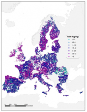
The JRC created a quantitative map of estimated soil pH values across Europe from a compilation of 12,333 soil pH measurements from 11 different sources, and using a geo-statistical framework based on Regression-Kriging. Fifty-four (54) auxiliary variables in the form of raster maps at 5km resolution were used to explain the differences in the distribution of soil pHCaCl2 and the kriged map of the residuals from the regression model was added. The goodness of fit of the regression model was satisfactory (R2adj = 0.43) and its residuals follow a Gaussian distribution. The lowest values correspond to the soils developed on acid rock (granites, quartzite’s, sandstones, etc), while the higher values are related to the presence of calcareous sediments and basic rocks. The validation of the model shows that the model is quite accurate (R2adj = 0.56). This shows the validity of Regression-Kriging in the estimation of the distribution of soil properties when a large and adequately documented number of soil measurements are available.
 |
Title: LUCAS 2022 TOPSOIL data | |
|
Resource Type: Datasets, Soil Point Data Theme/Sub-Theme: Soil Organic Carbon Content, Soil Nutrients, Soil pH, Soil Sampling |
Continent: Year: 2025 Publisher: European Commission Keywords: LUCAS, LUCAS SOIL, clay, silt, sand, coarse fragments, pH, OC, SOC, Organic Carbon Content, carbonates, CaCO3, nitrogen, phosphorous, potassium, N, P, K, EC, Electrical conductivity, Oxalate extractable Fe, Oxalate extractable Al |
|
|
Attachments:
|
||
 |
Title: LUCAS 2018 TOPSOIL data | |
|
Resource Type: Datasets, Soil Point Data Theme/Sub-Theme: Soil Organic Carbon Content, Soil Nutrients, Soil pH, Soil Sampling Registration requested: Request Form |
Continent: Year: 2022 Publisher: European Commission Keywords: LUCAS, LUCAS SOIL, clay, silt, sand, coarse fragments, pH, OC, SOC, Organic Carbon Content, carbonates, CaCO3, nitrogen, phosphorous, potassium, N, P, K, EC, Electrical conductivity, Oxalate extractable Fe, Oxalate extractable Al |
|
|
Attachments:
|
||
 |
Title: Maps of Soil Chemical properties at European scale based on LUCAS 2009/2012 topsoil data | |
|
Resource Type: Datasets, European Soil Database & soil properties Theme/Sub-Theme: Soil pH Registration requested: Request Form |
Continent: Year: 2019 Publisher: European Commission, Joint Research Centre (JRC) Language: EN Keywords: pH| Nitrogen| Phosphorus| Potassium |
|
|
|
||
 |
Title: Soil pH in Europe | |
|
Resource Type: Datasets, Soil Threats Data, Maps & Documents, Maps, Soil Data Maps Theme/Sub-Theme: Soil pH Registration requested: Request Form |
Continent: Year: 2010 Language: EN Keywords: pH |
|
|
Attachments:
|
||
|
|
Title: Soil pH in Europe | |
|
Resource Type: Datasets, Soil Threats Data, Maps & Documents, Maps, Soil Data Maps Theme/Sub-Theme: Soil pH Registration requested: Request Form |
Continent: Year: 2010 Language: EN Keywords: pH |
|
|
Attachments:
|
||