You are here
G2 Model
 | G2 model is a new model for erosion, resulted from the cooperation of Joint Research Centre/SOIL project and the Lab of Forest Management and Remote Sensing, School of Agriculture, Forestry and Natural Environment of the Aristotle University of Thessaloniki in the framework of geoland2 project. |
G2 is a quantitative model, mapping soil loss (G2los module) and sediment yield (G2sed module) on month-time intervals, designed to run in a GIS environment. A functional combination of G2 with Hakanson risk index has led to the introduction of a third module serving as a heavy metal spatial risk assessment module, namely the G2met.
Spatial scale of application in G2 is affected mainly by the topographic dataset, while temporal scale of G2 is set by default to month-time intervals.
G2los is an algorithm for producing month-time interval maps and statistics of soil loss caused by sheet and interrill erosion processes. The main erosion equation is:
Em = (Rm/Vm) * S * (T/L)
Where Em: soil loss for month m (t ha-1); Rm: rainfall erosivity of month m (MJ mm ha-1 h-1); Vm: vegetation retention for month m (dimensionless); S: soil erodibility (t ha h MJ-1 ha-1 mm-1); T: topographic influence (dimensionless); L: landscape effect (dimensionless).
The G2sed module is designed to map area-specific sediment yield (SSY) at a watershed scale on month-time intervals, according to the following:
SSYm = SDR * Em
Where, SSYm: area-specific sediment yield during month m (t ha-1); SDR: sediment delivery ratio, in range [0,1] (values differentiated per watershed, dimensionless); Em: soil loss rate for month m (t ha-1).
G2 is designed to produce soil loss maps as raster layers at a 100-m resolution and sediment yield maps as vector layers at a 100-ha minimum mapping unit (MMU), on a month-time step. Several published studies of G2 implementation, e.g. in the cross-borders basin of river Strymonas/Struma (Greece and Bulgaria), in the basin of rivers Ishmi and Erzeni (Albania), in Korce (Albania), in the Mediterranean island of Crete (Greece), in the Cyprus island have provided realistic results.
For details in erosion factor and SDR calculations, you may refer to:
Karydas, C.G. and Panagos, P. 2018. The G2 erosion model: An algorithm for month-time step assessments, Environmental Research, 161: 256-267.
Download the Data
To get access to the data, please compile the Request form; instructions will then follow how to download the data. Soil erosion layers (Total & Monthly) plus Rainfall erosivity (Total & Monthly), vegetation retention (Total & Monthly), soil erodibility, topographic influence and slope intercept are available for the five (5) application areas:
- Cyprus: 9251 Km2 - pixel size: 100m including sediment module
- Crete island: 8336 Km2 (Greece) - Pixel size: 300m.
- Ishmi-Erzeni watershed : 2,200 Km2 (Albania) - Pixel size: 300m.
- Korce Region: 1690 Km2 (Albania) - Pixel size: 30m
- Strymonas/Struma Catchment : 14.500 Km2 (Greece / Bulgaria) - Pixel size: 300m.
More Information - Links
A complete description of the G2 model and relevant applications (Strymonas, Crete, Albania) are provided in the following papers:
- Karydas, C.G. and Panagos, P. 2018. The G2 erosion model: An algorithm for month-time step assessments, Environmental Research, 161: 256-267
- Karydas, C.G., Panagos, P. 2016. Modelling monthly soil losses and sediment yields in Cyprus. International Journal of Digital Earth, 9(8): 766-787
- Zdruli, P, Karydas, CG, Dedaj, K, Salillari, I, Cela, F, Lushaj, S, Panagos, P (2016). High resolution spatiotemporal analysis of erosion risk per land cover category in Korçe region, Albania. Earth Science Informatics, 9(4): 481-495
- Panagos, P., Karydas, CG., Ballabio, C., Gitas, IZ., 2014. Seasonal monitoring of soil erosion at regional scale: An application of the G2 model in Crete focusing on agricultural land uses. International Journal of Applied Earth Observations and Geoinformation 27PB: 147-155, DOI: 10.1016/j.jag.2013.09.012.
- Panagos, P., Karydas, CG., Gitas, IZ., Montanarella, L, 2012. Monthly soil erosion monitoring based on remotely sensed biophysical parameters: a case study in Strymonas river basin towards a functional pan-European service. International Journal of Digital Earth. 5(6): 461-487 . Request a reprint from the Authors
- Karydas, CG, P Panagos, IZ Gitas. 2014. A classification of water erosion models according to their geospatial characteristics, International Journal of Digital Earth 7(3), 229-250 (DOI: 0.1080/17538947.2012.671380). Request a reprint from the Authors.
A additional list of publications using the G2 model (Iran, Australia Serbia, Poland, Albania, Italy) are provided in the following papers:
- Mohammadi, S., Balouei, F., Haji, K., Khaledi Darvishan, A. Karydas, C.G. (2021): Country-scale spatio-temporal monitoring of soil erosion in Iran using the G2 model, International Journal of Digital Earth, 14(8), 1019-1039
- Karydas, C.; Bouarour, O.; Zdruli, P. (2020). Mapping Spatio-Temporal Soil Erosion Patterns in the Candelaro River Basin, Italy, Using the G2 Model With Sentinel2 Imagery. Geosciences, 10, 89
- Karydas, C.G., Zdruli, P., Koci, S., Sallaku, F. (2015a). Monthly time-step erosion risk monitoring of Ishmi-Erzeni watershed, Albania using the G2 model. Environmental Modeling & Assessment, 20(6): 657-671
- Halecki, W., Kruk, E., Ryczek, M. (2018). Evaluation of water erosion at a mountain catchment in Poland using the G2 model, CATENA, 164.
- Jeanneau, A., Herrmann, T., Ostendorf, B. (2021). Mapping the spatio-temporal variability of hillslope erosion with the G2 model and GIS: A case-study of the South Australian agricultural zone, Geoderma, 402.
- Polovina, S.; Radić, B.; Ristić, R.; Kovačević, J.; Milčanović, V.; Živanović, N. (2021). Soil Erosion Assessment and Prediction in Urban Landscapes: A New G2 Model Approach. Applied Sciences, 11, 4154.
Download a user guide - presentation of G2 model.

Figure 1. Crete island, Greece; the Annual Erosion Map (t/ha) resulting from the month-step erosion maps.

Figure 2. Ishmi-Erzeni watershed (Albania): the Annual Erosion Map (t/ha) resulting from the month-step erosion maps
 | 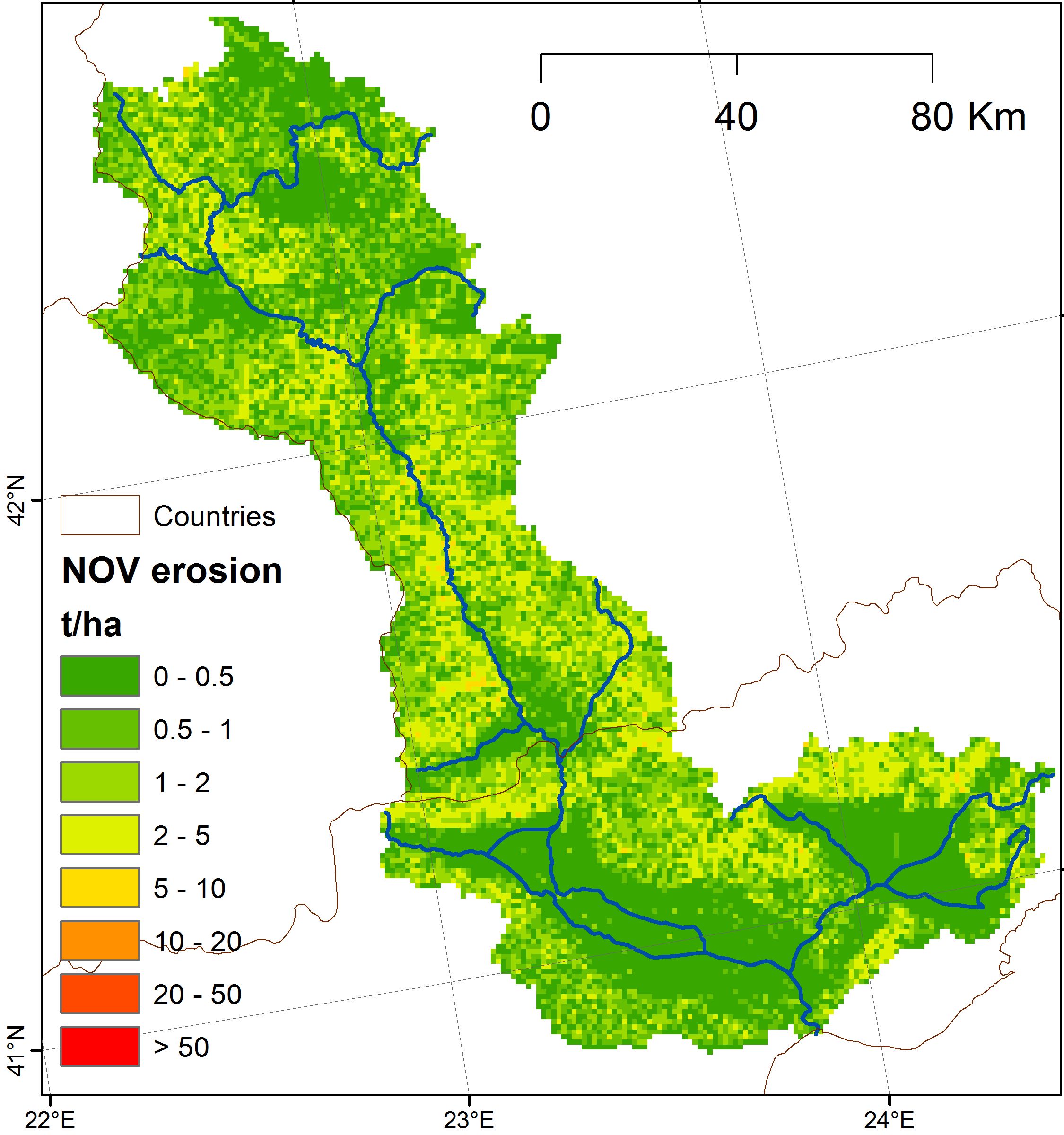 |
Figure 3. Strymonas/Struma catchment, Greece/Bulgaria: Indicative Month-step Erosion Maps (t/ha) (May, November).
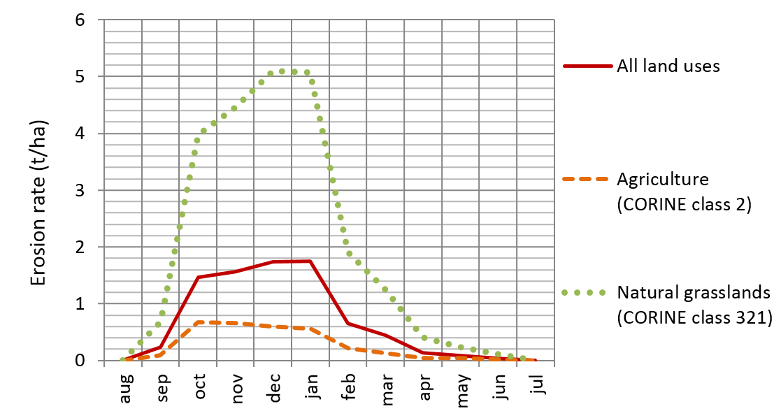
Figure 4. Temporal distribution of erosion rates in Crete for all land uses, agricultural land use and natural grasslands.

Fig. 5: Map of the adjusted SDR values of Cyprus per sub-basin.
Go Back To
|
|
Title: G2 soil erosion model data | |
|
Resource Type: Datasets, Soil Projects Data Theme/Sub-Theme: Erosion by water, G2 Model Registration requested: Request Form |
Continent: Country: Afghanistan Author: xfgvccb, vbbv Year: 2013 Publisher: JRC and Aristotle University of Thessaloniki Keywords: erosion; G2; modelling; USLE; Spatio-Temporal mapping; Critical zones; Crete; Cyprus; Albania; Strymonas |
|
|
|
||