You are here
Global Soil Erosion
GLoSEM - Glonal Soil Erosion Modelling platform
Global Soil Erosion Modelling platform (GloSEM) 1.0 uses three land use types: Cropland, Forest and natural areas based on the probabilistic land allocation process. More details in the paper in Nature Communications.GloSEM is the first global modelling platform to take into account regional farming systems, the mitigation effects of conservation agriculture (CA), and climate change projections. We provide a set of data, maps and descriptive statistics to support researchers and decision-makers in exploring the extent and geography of soil erosion, identifying probable hotspots, and exploring (with stakeholders) appropriate actions for mitigating impacts.
In GloSEM 1.2, the perennial crops, managed pasture and temporary forest loss are spatially delineated through a probabilistic land use allocation scheme to outline the global cropland better than in the GloSEM 1.0. More details about GloSEM 12. in the paper in PNAS publication and in the chapter of Global Land Degradation book.
in GloSEM 1.3, we make model at 100m resolution (compared to the 1km in the previous GloSEM) and we use the land uses provided by European Spatial Agency (ESA) and make available the soil displacement under different climate scenarios (RCPs) for 2070. More details in the paper in Scientific Data.
The outcomes stemming from GloSEM have been used by researchers in adjacent disciplines to map the world’s free-flowing rivers, quantify the negative cascading effects of soil erosion on nutrient loss, create a link between soil erosion and economic models, measure land degradation and consider alternative strategies for coral-reef conservation among other things.
An Assessment of the global impact of 21st century land use change on soil erosion
Human activity and related land use change are the primary cause of accelerated soil erosion, which has substantial implications for nutrient and carbon cycling, land productivity and in turn, worldwide socio-economic conditions. Here we present an unprecedentedly high resolution (250 × 250 m) global potential soil erosion model, using a combination of remote sensing, GIS modelling and census data. We challenge the previous annual soil erosion reference values as our estimate, of 35.9 Pg yr−1 of soil eroded in 2012, is at least two times lower. Moreover, we estimate the spatial and temporal effects of land use change between 2001 and 2012 and the potential offset of the global application of conservation practices. Our findings indicate a potential overall increase in global soil erosion driven by cropland expansion. The greatest increases are predicted to occur in Sub-Saharan Africa, South America and Southeast Asia. The least developed economies have been found to experience the highest estimates of soil erosion rates.
Main highlights
- Modelled area: 125 million Km2 which is about 84.1% of Earth's land
- 202 countries included in the study
- 35 Pg yr−1 of soil eroded in 2001. The estimates are lower compared to past studies
- in 2012, 35.9 Pg yr−1 - Increase of 2.5% in soil erosion globally (due to land use change)
- Cropland total annual average soil erosion : 17 (-0.7, +1) Pg yr−1
- Gross Soil Organic carbon displacement by water erosion ca. 2.5 Pg C yr−1
Global perspective on soil erosion
Our baseline model predicts an annual average potential soil erosion amount of 35 Pg yr−1 for 2001, with an area-specific soil erosion average of 2.8 Mg ha−1 yr−1. In 2012, we estimated an overall increase of 2.5% in soil erosion (35.9 Pg yr−1), driven by spatial changes of land use. According to the baseline scenario,at a continental level, South America shows the highest prediction of average soil erosion rate (3.53 Mg ha−1 yr−1) in 2001, followed by Africa (3.51 Mg hha−1 yr−1 and Asia (3.47 Mg ha−1 yr−1). North America, Europe and Oceania show considerably lower predicted values, totalling 2.23, 0.92 and 0.9 Mg ha−1 yr−1, respectively. In 2012, the latter group of continents indicated an estimated decreasing trend of soil erosion driven by land use change, with the highest decrease predicted in North America (4.8%). For Asia, we predict a slight increase of about one percent, mainly driven by a noticeable increase in soil erosion in the Southeast Asian countries. China (~2%) and India (~0.45%), in contrast, even though densely populated show a decrease in soil erosion estimates, while we observe a noteworthy increase in soil erosion in South America and Africa. Africa surpasses South America with an estimated increase of soil erosion of ~10% in 2012, thus becoming the continent with the highest average soil erosion rate (3.88 Mg ha−1 yr−1).

Land use/cover and soil erosion
We assessed the dynamics in land use between 2001 and 2012. This resulted in a forest decline (~1.65 million km2), an expansion of the semi-natural vegetation (savannah, scrublands, grassland, transition forest) (~1.43 million km2) and an expansion of cropland (~0.22 million km2). A total of 2.26 million km2 of forests are estimated to be lost during the study period, mostly replaced by semi-natural vegetation (2.17 million km2) and to a lesser extent by cropland (~0.1 million km2). In the baseline scenario, the change from forest to other land uses caused an increase of 0.61 Pg yr−1 of soil erosion. The substitution of forests for cropland (4.1% of the forest lost) is responsible for about 52% of this increase in soil loss. At the same time, a forest area gain of about 0.61 million km2 occurred during the study period, resulting in a net loss of ~1.65 million km2.
The area which had undergone a change during the study period totalled about 3.3% of the study area (equal to ~4 million km2), 2.9 million km2, of which ~2.4% showed an increase in the estimates of soil erosion of 1.74 Pg yr−1. The remaining 1.1 million km2 (~0.9%) under land use change experienced a decrease in soil erosion of 0.88 Pg yr−1. This results in an estimated overall increase of soil erosion for areas with land use change of about 0.86 Pg yr−1.

Conservation agriculture and soil erosion
The conservation agriculture covers about 15.3% of the observed cropland (1.6 of 10.3 million km2), resulting in an estimated overall soil erosion reduction of about 7% compared to the baseline scenario in 2012 (from 10.93 to 10.15 Pg yr−1). At a continental level, the highest soil erosion reductions are estimated in South America (16%), Oceania (15.4%), North America (12.5%), and to a lesser extent in Europe (1.5%), Asia (1.2%) and Africa (1.1%).
Data and additional material
The 25km (re-sampled data) and the input layers (K-factor, Ls-factor, R-factor, C-factor) are available in the European Soil Data Centre (ESDAC). The shared files include both the data for 2012 and 2001. Data are accessible in Global Soil Erosion.
GloSEM 1.3. High-resolution global estimates of present and future soil displacement in croplands by water erosion
An example of the high resolution 250mx250m soil loss maps and their ability to detect anthropogenic disturbances is provided for comparison (location - Amazon rainforest, headwater of the Madeira River) is also provided. This example show the "original" data at 250m modelled in this study. In case researchers/policy makers have specific requests with high priority or proposals for joint collaborations to develop new studies with the high resolution data, then please contact Pasquale Borrelli (Univeristy of Roma3) or Panos Panagos. However, we cannot ensure that we can cover the requests due to heavy workload.
Aggregated data at country level: We have used the Global Soil Erosion data to estimate the mean values per country
| Year | Soil Loss by water erosion (t ha-1 yr-1) - mean values per country |
| 2001, 2012 | Mean water erosion per country |
In the article supplementary information, there is detailed description for the model and the data inputs.
Reference:
Borrelli P., Robinson D.A., Fleischer L.R., Lugato E., Ballabio C., Alewell C., Meusburger K., Modugno, S., Schutt, B. Ferro, V. Bagarello, V. Van Oost, K., Montanarella, L., Panagos P. 2017. An assessment of the global impact of 21st century land use change on soil erosion. Nature Communications, 8 (1): art. no. 2013

Go Back To
 |
Title: Global Soil Organic Carbon displaced due to erosion | |
|
Resource Type: Datasets, Soil Threats Data Theme/Sub-Theme: Erosion by water, Global Soil Erosion Registration requested: Request Form |
Continent: Year: 2025 Keywords: SOC losses |
|
|
|
||
|
|
Title: Erosion potential method (EPM) | |
|
Resource Type: Datasets, Soil Threats Data Theme/Sub-Theme: Erosion by water, Global Soil Erosion Registration requested: Request Form |
Continent: Year: 2024 Keywords: erosion potential |
|
|
|
Title: Global Soil Erodibility | |
|
Resource Type: Datasets, Soil Threats Data Theme/Sub-Theme: Erosion by water, Global Soil Erosion Registration requested: Request Form |
Continent: Year: 2023 Keywords: soil erodibility |
|
 |
Title: Multiple co-occurring erosion processes on global cropland | |
|
Resource Type: Datasets, Soil Threats Data Theme/Sub-Theme: Erosion by water, Global Soil Erosion Registration requested: Request Form |
Continent: Year: 2023 |
|
|
|
||
 |
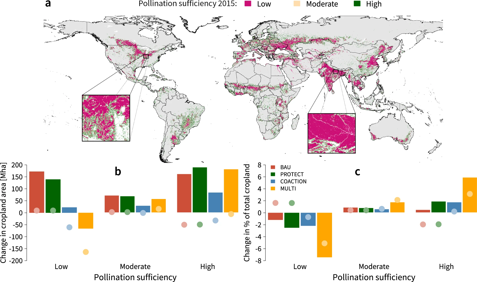
Title: Projected Land Conservation Impacts on Global Soil Erosion and Pollination Sufficiency | |
|
Resource Type: Datasets, Soil Functions Data, Soil Threats Data Theme/Sub-Theme: Erosion by water, Global Soil Erosion Registration requested: Request Form |
Continent: Year: 2023 |
|
|
|
Title: Global rainfall erosivity projections for 2050 and 2070 | |
|
Resource Type: Datasets, Soil Threats Data Theme/Sub-Theme: Erosion by water, Global Soil Erosion, Global Soil Erosion – Future projections Registration requested: Request Form |
Continent: Year: 2022 |
|
") |
Title: High resolution cropland africa soil erosion (GloSEM 1.3) | |
|
Resource Type: Datasets, Soil Threats Data Theme/Sub-Theme: Erosion by water, Global Soil Erosion Registration requested: Request Form |
Continent: Year: 2022 |
|
|
|
Title: Land degradation in global arable lands | |
|
Resource Type: Datasets, Soil Threats Data Theme/Sub-Theme: Erosion by water, Global Soil Erosion, Land degradation Registration requested: Request Form |
Continent: Year: 2021 Language: EN Keywords: aridity |
|
 |
Title: Global Soil Erosion | |
|
Resource Type: Datasets, Soil Threats Data Theme/Sub-Theme: Erosion by water, Global Soil Erosion Registration requested: Request Form |
Continent: Country: Italy Year: 2019 Publisher: Joint Research Centre of the European Commission Language: EN Keywords: Soil Erosion, land use, global |
|
|
Attachments:
|
||