You are here
Soil Erodibility in Europe
What is soil erodibility?
| The greatest obstacle to soil erosion modelling at larger spatial scales is the lack of data on soil characteristics. One key parameter for modelling soil erosion is the soil erodibility, expressed as the K-factor in the widely used soil erosion model, the Universal Soil Loss Equation (USLE) and its revised version (RUSLE). The K-factor, which expresses the susceptibility of a soil to erode, is related to soil properties such as organic matter content, soil texture, soil structure and permeability.The K-factor is a lumped parameter that represents an integrated annual value of the soil profile reaction to the process of soil detachment and transport by raindrops and surface flow (Renard et al., 1997). As such soil erodibility is best estimated by carrying out direct measurements on field plots (Kinnell, 2010). However, since field measurements are expensive and often not easily transferable in space, researchers investigated the relation between “classical” soil properties and soil erodibility. |  |
A new approach for K-factor estimation
 | With the Land Use/Cover Area frame Survey (LUCAS) soil survey in 2009 a pan-European soil dataset is available for the first time, consisting of around 20,000 points across 25 Member States of the European Union. The LUCAS (Land Use/Cover Area frame Survey) is an in-situ assessment, whichmeans that the data is gathered through direct field observations. The aimof the LUCAS survey is to establish a fully harmonised database within the EU on land use/cover and to document changes over time. A soil module was included in the LUCAS dataset for the first time in 2009.
An algebraic approximation of the nomograph that includes five soil parameters (texture, organic matter, coarse fragments, structure, and permeability) is proposed by Wischmeier and Smith (1978) and Renard et al. (1997) in equation (1): K = [(2.1 x 10⁻⁴ M1.14 (12 – OM) +3.25 (s -2) + 2.5 (p - 3) ) / 100 ] * 0.1317 (1) Where: M : the textural factor with M = (msilt + mvfs) * (100 - mc ); mc [%]: clay fraction content (<0.002 mm); msilt [%]: silt fraction content (0.002 – 0.05 mm); mvfs [%]: very fine sand fraction content (0.05 – 0.1 mm); OM [%]: the organic matter content; s: the soil structure class (s=1: very fine granular, s=2: fine granular, s=3, medium or coarse granular, s=4: blocky, platy or massive); p: the permeability class (p=1: very rapid, …, p=6: very slow).
The high-resolution soil erodibility map (500m) version 2014 incorporates certain improvements over the coarse-resolution map (10km) version 2011:
|
K-factor High-resolution dataset (500m) - Version 2014
The aim of this study is the generation of a harmonised high-resolution soil erodibility map (with a grid cell size of 500 m) for the 25 EU Member States. Soil erodibility was calculated for the LUCAS survey points using the nomograph of Wischmeier and Smith (1978). A Cubist regression model was applied to correlate spatial data such as latitude, longitude, remotely sensed and terrain features in order to develop a high-resolution soil erodibility map. The mean K-factor for Europe was estimated at 0.032 t ha h ha-1 MJ-1 mm-1 with a standard deviation of 0.009 t ha h ha-1 MJ-1 mm-1. The yielded soil erodibility dataset compared well with the published local and regional soil erodibility data. However, the incorporation of the protective effect of surface stone cover, which is usually not considered for the soil erodibility calculations, resulted in an average 15% decrease of the K-factor. The exclusion of this effect in K-factor calculations is likely to result in an overestimation of soil erosion, particularly for the Mediterranean countries, where highest percentages of surface stone cover were observed.
The soil erodibility dataset overcomes the problems of limited data availability for K-factor assessment and presents a high quality resource for modellers who aim at soil erosion estimation on local/regional, national or European scale. The new proposed dataset has also been verified against local/regional/national studies with very good results. Soil erosion modellers (and not only) may use it for their applications at any scale.
Data
The Soil Erodibility Dataset is in Raster format. The public user can download 3 different datasets: a) Soil erodibility in Europe (K-factor), b) Soil Erodibility incorporating Stoniness (Kst Factor) and c) the Effect of Stoniness in K-factor (% reduction). To get access to the data, please compile the online form; instructions will then follow how to download the data. ![]() (Mar 2015) K-factor values are available for the 28 European Union Member States (including Bulgaria, Romania, Croatia) as in Figure 2. Due to a number of requests from non-EU users, we also make available the Extrapolated datasets covering also Norway, Switzerland, Balkan states, Moldova and Ukraine.
(Mar 2015) K-factor values are available for the 28 European Union Member States (including Bulgaria, Romania, Croatia) as in Figure 2. Due to a number of requests from non-EU users, we also make available the Extrapolated datasets covering also Norway, Switzerland, Balkan states, Moldova and Ukraine.
 |  |
| Fig. 1: K-factor high resolution(2014) | Fig. 2: K-factor in 28 Member States (2015) |
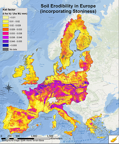 |  |
| Fig. 3: K-factor incrorporating Stoniness | Fig. 4: Effect of Stoniness in K-factor (% reduction) |
References:
A complete description of the methodogoly (High resolution - 2014 version) and the application in Europe is described in the paper:
Panagos, P., Meusburger, K., Ballabio, C., Borrelli, P., Alewell, C.
Soil erodibility in Europe: A high-resolution dataset based on LUCAS, Science of Total Environment, 479–480 (2014) pp. 189–200
Download the article (Open Access): 10.1016/j.scitotenv.2014.02.010
Due to a number of requests from non-EU users, we also make available the Extrapolated datasets covering also Norway, Switzerland, Balkan states, Moldova and Ukraine.
Go Back To
 |
Title: Biodiversity factor in soil erosion | |
|
Resource Type: Datasets, Soil Threats Data Theme/Sub-Theme: Erosion by water, Soil Erodibility in Europe, Soil Biodiversity, Integrated Soil Modelling, Soil biodiversity and soil erosion Network/Cooperations: European Network on Soil Awareness, Educational Material on soils |
Continent: Year: 2018 Publisher: Joint Research Centre of the European Commission Language: EN Keywords: soil biodiversity |
|
") |
Title: Soil erosion by water (RUSLE2015) | |
|
Resource Type: Datasets, Soil Threats Data Theme/Sub-Theme: Erosion by water, Europe (Baseline), Soil Erodibility in Europe, Rainfall Erosivity in Europe, Cover Management Factor, Support Practices Factor, Slope Length and Steepness factor (LS-factor) Registration requested: Request Form |
Continent: Year: 2015 Keywords: RUSLE, soil erodibility, rain erosivity, Management practices, agricultural sustainability, policy scenarios |
|
|
|
||
 High Resolution dataset for Europe") |
Title: Soil Erodibility (K- Factor) High Resolution dataset for Europe | |
|
Resource Type: Datasets, Soil Threats Data Theme/Sub-Theme: Erosion by water, Soil Erodibility in Europe Registration requested: Request Form |
Continent: Year: 2014 Publisher: Joint Research Centre of the European Commission Keywords: K-Factor |
|
|
|
||