JOINT RESEARCH CENTRE
European Soil Data Centre (ESDAC)
Soil profiles
Displaying 1 - 14 of 14 |
 |
Title: Soil Survey Niger Floodplain. Jebba-Lokoja. Schematic Cross-Sections. Part 7. Figure. 10. | |
|
Resource Type: National Soil Maps (EUDASM), Maps, Maps & Documents |
Continent: Africa Country: Niger Publisher: Balfour, Beatty & Co. Ltd. London. NEDECO, The Hague. Language: En Keywords: Soil profiles |
|
|
|
||
 |
Title: Soil Survey Niger Floodplain. Jebba-Lokoja. Cross-Sections Pilot Area. 1:20,000. Part 7. Figure. 5.1. | |
|
Resource Type: National Soil Maps (EUDASM), Maps, Maps & Documents |
Continent: Africa Country: Niger Publisher: Balfour, Beatty & Co. Ltd. London. NEDECO, The Hague. Language: En Keywords: Soil profiles |
|
|
|
||
 |
Title: Soil Survey Niger Floodplain. Jebba-Lokoja. Cross-Sections Pilot Area. 1:20,000. Part 7. Figure. 5.2. | |
|
Resource Type: National Soil Maps (EUDASM), Maps, Maps & Documents |
Continent: Africa Country: Niger Publisher: Balfour, Beatty & Co. Ltd. London. NEDECO, The Hague. Language: En Keywords: Soil profiles |
|
|
|
||
 |
Title: Lower Volta Flood Plain Survey. Typical Arrangements. Field Layouts Canal Longitudinal & Cross-Sectios. Drawing No. 6. | |
|
Resource Type: National Soil Maps (EUDASM), Maps, Maps & Documents |
Continent: Africa Country: Ghana Author: Sir William Halcrow & Partners Consulting Engineers Alliance House, Caxton Street Westminster, London. Year: 1962 Publisher: Land & Water Development Division. Food & Agriculture Organization. Language: En Keywords: Soil profiles |
|
|
|
||
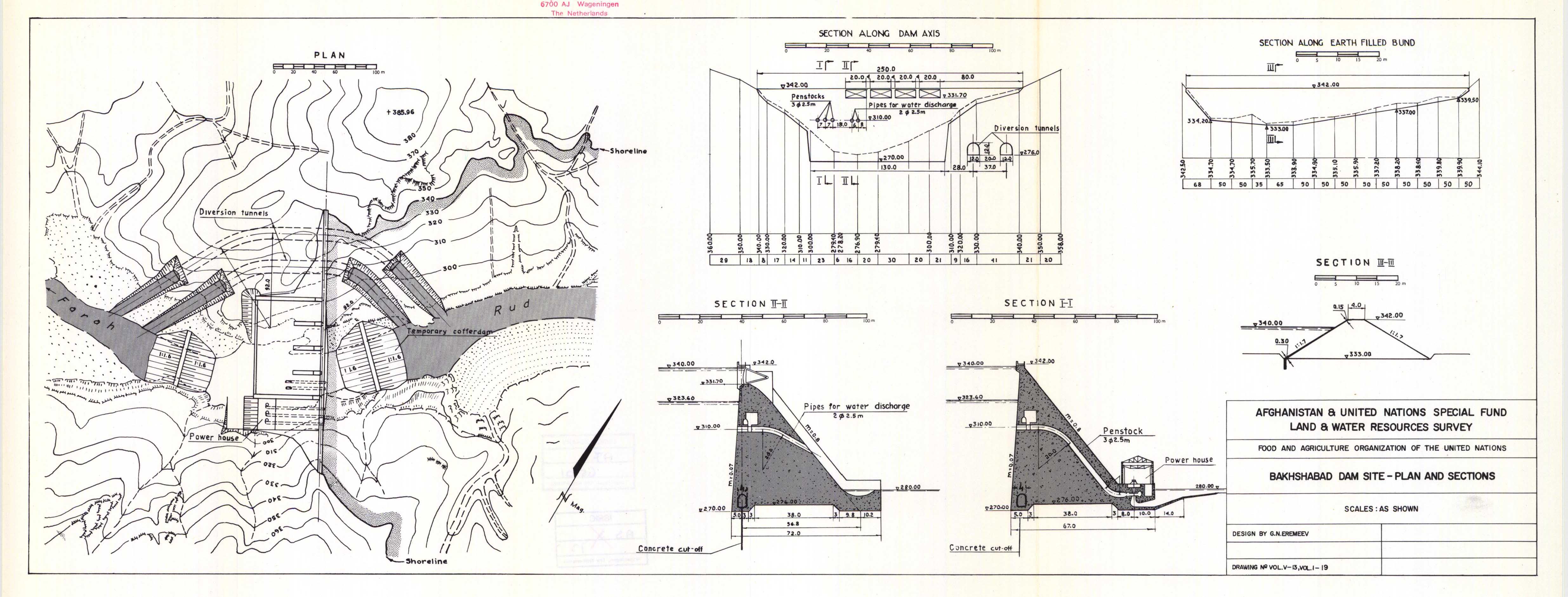 |
Title: Bakhshabad Dam Site-Plan and Sections. Vol. No. V-13, Vol. I-19. | |
|
Resource Type: National Soil Maps (EUDASM), Maps, Maps & Documents |
Continent: Asia Country: Afghanistan Publisher: Afghanistan & United Nations Special Fund Land & Water Resources Survey. Language: En Keywords: Soil profiles |
|
|
|
||
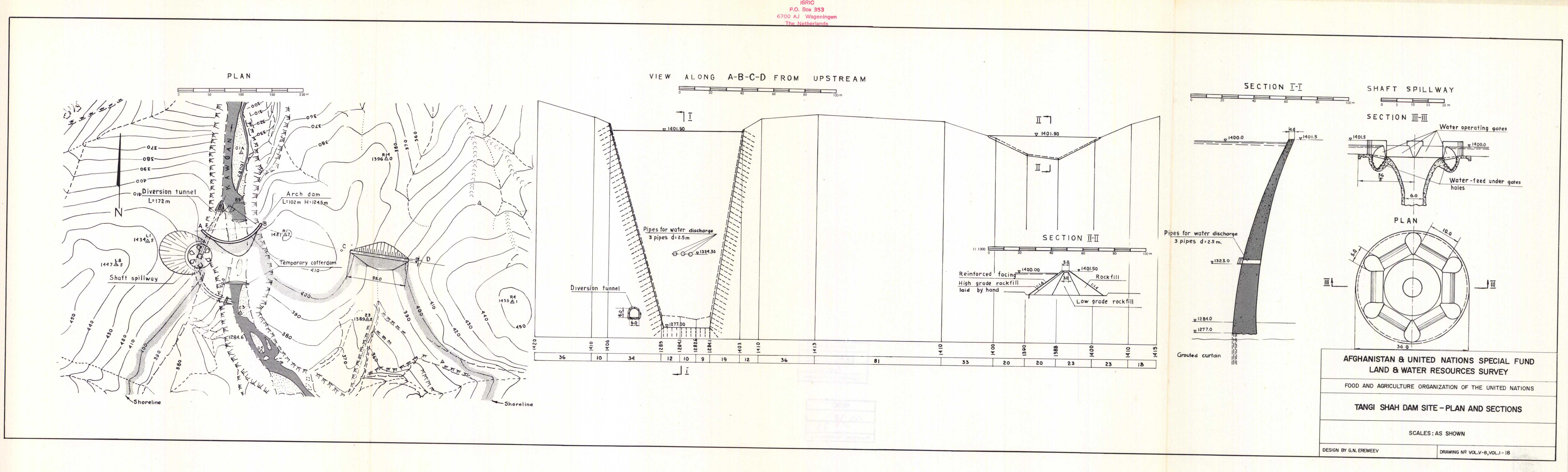 |
Title: Tangi Shah Dam Site-Plan and Sections. Vol. No. V-8, Vol. I-18. | |
|
Resource Type: National Soil Maps (EUDASM), Maps, Maps & Documents |
Continent: Asia Country: Afghanistan Publisher: Afghanistan & United Nations Special Fund Land & Water Resources Survey. Language: En Keywords: Soil profiles |
|
|
|
||
 |
Title: Kajaw Dam Site-Plan and Sections. Vol. No. V-23, Vol. I-23. | |
|
Resource Type: National Soil Maps (EUDASM), Maps, Maps & Documents |
Continent: Asia Country: Afghanistan Publisher: Afghanistan & United Nations Special Fund Land & Water Resources Survey. Language: En Keywords: Soil profiles |
|
|
|
||
 |
Title: Salma Dam Site-Plan and Sections. Vol. No. V-6, Vol. I-17. | |
|
Resource Type: National Soil Maps (EUDASM), Maps, Maps & Documents |
Continent: Asia Country: Afghanistan Publisher: Afghanistan & United Nations Special Fund Land & Water Resources Survey. Language: En Keywords: Soil profiles |
|
|
|
||
 |
Title: Lashkargah Dam Site-Plan and Sections. Vol. No. V-17, Vol. I-21. | |
|
Resource Type: National Soil Maps (EUDASM), Maps, Maps & Documents |
Continent: Asia Country: Afghanistan Publisher: Afghanistan & United Nations Special Fund Land & Water Resources Survey. Language: En Keywords: Soil profiles |
|
|
|
||
 |
Title: Aliki Dam Site-Plan and Sections. Vol. No. V-15, Vol. I-20. | |
|
Resource Type: National Soil Maps (EUDASM), Maps, Maps & Documents |
Continent: Asia Country: Afghanistan Publisher: Afghanistan & United Nations Special Fund Land & Water Resources Survey. Language: En Keywords: Soil profiles |
|
|
|
||
 |
Title: Tangi Saidan Dam Site-Plan and Sections. Vol. No. V-20, Vol. I-22. | |
|
Resource Type: National Soil Maps (EUDASM), Maps, Maps & Documents |
Continent: Asia Country: Afghanistan Publisher: Afghanistan & United Nations Special Fund Land & Water Resources Survey. Language: En Keywords: Soil profiles |
|
|
|
||
 |
Title: Assarasum Dam Site Rock Fill Plan and Sections. | |
|
Resource Type: National Soil Maps (EUDASM), Maps, Maps & Documents |
Continent: Asia Country: Afghanistan Publisher: Afghanistan & United Nations Special Fund Land & Water Resources Survey. Language: En Keywords: Soil profiles |
|
|
|
||
 |
Title: Upper Hari Rud and Kawgan Tributary Outline Map. | |
|
Resource Type: National Soil Maps (EUDASM), Maps, Maps & Documents |
Continent: Asia Country: Afghanistan Publisher: Afghanistan & United Nations Special Fund Land & Water Resources Survey. Language: En Keywords: Soil profiles |
|
|
|
||
 |
Title: Assarasum Dam Site Concrete Buttress Plan and Sections. Vol. No. V-3, Vol. I-15. | |
|
Resource Type: National Soil Maps (EUDASM), Maps, Maps & Documents |
Continent: Asia Country: Afghanistan Publisher: Afghanistan & United Nations Special Fund Land & Water Resources Survey. Language: En Keywords: Soil profiles |
|
|
|
||